|

from
Flem-Ath Website
|
This account is based on an unpublished manuscript
(ATLANTIS AT
LAST!) which was registered with the Library of Congress on the 18th
of August 1980 |
Plato’s account of Atlantis records a conversation that had taken
place two centuries before when his ancestor, Solon, travelled to
Egypt (around 560 B.C.). During this trip Solon learned from an
Egyptian priest who described a 9,000 year old depiction of the
geography of Atlantis as if you were standing on the shores of
Atlantis:
"In those far-away days that Ocean could be navigated, as there was
an island outside the channel which your countrymen tell me you call
the ’pillars of Heracles’. This island was larger than Libya and
Asia together, and from it seafarers, in those times, could make
their way to the others, and thence to the whole opposite continent,
which encircles the true outer Ocean. (The waters within the channel
just mentioned are manifestly a basin with a narrow entrance; what
lies beyond it is the real Ocean, and it is land enclosing that
Ocean which should rightly be called a Continent.)"
The U.S. Naval projection shows the world as seen
FROM the shores of
Antarctica. In the following map the U.S. Naval projection is
modified to include the landmasses as they were around 9,600 B.C.
(when Atlantis was said to have been destroyed).
Antarctica has been
replaced by Kircher’s map of Atlantis (Egyptian Map of Antarctica).
Below the map is a modern rendering of Plato’s words replacing
Atlantis with Antarctica.
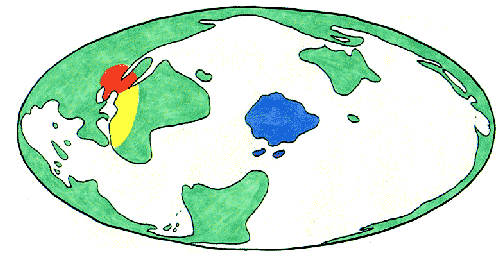
Long ago the World Ocean was navigated beyond the
Straits of
Gibraltar by sailors from an island larger than North Africa and the
Middle East combined. After leaving Antarctica you would encounter
the Antarctic archipelago (islands currently under ice) and from
them you reach the World Continent (Afro-Eur-Asia joined with North
and South America) which encircles the World Ocean. The
Mediterranean Sea is very small compared to the World Ocean and
could even be called a bay. But beyond the Mediterranean Sea is a
World Ocean which is encircled by one continuous landmass
(geographic sense of "continent").
Atlantis, in the center, is described by the Egyptian priest as
being "larger than Libya and Asia together". Libya, during
Solon’s
time was what we call today "North Africa" and
Asia meant what we
call today "the Middle East". The boundaries of
Atlantis stretched
to cover more than five million square miles, a massive land, larger
than the United States. It is hard to take seriously, theories which
attempt to squeeze a continent of this immense size into the
Mediterranean Sea, which holds less than one million square miles of
water.
It seems absurd to believe that a massive continent dominated by
immense mountains, could slide quietly into the ocean like some
crippled submarine, and disappear without a trace. Yet those who
persistently argue for a North Atlantic Atlantis would have us
believe that such a quiet, disappearing act took place less than
12,000 years ago.
Atlantis was lost partly because we lost the original meaning of the
term "Atlantic Ocean". For the Greeks of Solon’s time the
Atlantic
Ocean was a body of water that completely surrounded the world. It
was only later when the age of exploration discovered (or invented)
new oceans that Atlantic came to mean just the water between
Europe/Africa and North/South America. Atlantic Ocean in Solon’s
time was the World Ocean that oceanographers teach us today.
The astonishing significance of Plato’s account of Atlantis is the
remarkable fact that in three short sentences he describes with
amazing accuracy the fundamental geographic features of our planet
as seen from Antarctica. Somewhere and somehow amidst the
chaos of
history, perhaps as a dying legacy, the Atlantean entrusted their
world view to the priests of ancient Egypt. One of these priests
disclosed this secret geography to Plato’s ancestor, Solon. This
ancient, yet accurate depiction of our planet proves that not only
did Atlantis exist on Antarctica, but it was an
advanced
civilization, capable of conceptualizing and mapping the entire
planet.
|