|
Chapter 7
-
Were There Giants Then?
Just after six in the morning the little train jerked into motion
and began its slow climb up the steep sides of the valley of Cuzco.
The narrow-gauge tracks were laid out in a series of Z shapes. We
chugged along the lower horizontal of the first Z, then shunted and
went backwards up the oblique, shunted again and went forward along
the upper horizontal— and so on, with numerous stops and starts,
following a route that eventually took us high above the ancient
city.
The Inca walls and colonial palaces, the narrow streets, the
cathedral of Santo Domingo squatting atop the ruins of Viracocha’s
temple, all looked spectral and surreal in the pearl-grey light of a
dawn sky. A fairy pattern of electric lamps still decorated the
streets, a thin mist seeped across the ground, and the smoke of
domestic fires rose from the chimneys over the tiled roofs of
countless small houses.
Eventually the train turned its back on Cuzco and we proceeded for a
while in a straight north-westerly direction towards our
destination:
Machu Picchu, the lost city of the Incas, some three
hours and 130 kilometers away. I had intended to read, but lulled by
the rocking motion of the carriage, I dropped off to sleep instead.
Fifty minutes later I awoke to find that we were passing through a
painting. The foreground, brightly sunlit, consisted of flat green
meadows sprinkled with little patches of thawing frost, distributed
on either side of a stream across a long, wide valley.
In the middle of my view, dotted with bushes, was a large field on
which a handful of black and white dairy cows grazed. Nearby was a
scattered settlement of houses outside which stood small,
dark-skinned Quechua Indians dressed in ponchos, balaclavas and
colourful woollen hats. More distant were slopes canopied in fir
trees and exotic eucalyptus. My eye followed the rising contours of
a pair of high green mountains, which then parted to reveal folded
and even more lofty uplands. Beyond these soared a far horizon
surmounted by a jagged range of radiant and snowy peaks.
Casting down the giants
It was with understandable reluctance that I turned at last to my
reading. I wanted to look more closely at some of the curious links
I thought I had identified connecting the sudden appearance of
Viracocha to the
deluge legends of the Incas and other Andean
peoples.
Before me was a passage from Fr. Jose de Acosta’s Natural and Moral
History of the Indies, in which the learned priest set out ‘what the
Indians themselves report of their beginning’:
They make great mention of a deluge, which happened in their country
... The Indians say that all men were drowned in the deluge, and
they report that out of Lake Titicaca came one Viracocha, who stayed
in Tiahuanaco, where at this day there are to be seen the ruins of
ancient and very strange buildings, and from thence came to Cuzco,
and so began mankind to multiply ...1
Making a mental note to find out more about Lake Titicaca, and the
mysterious
Tiahuanaco, I read the following passage summarizing a
legend from the Cuzco area:
For some crime unstated the people who lived in the most ancient
times were destroyed by the creator ... in a deluge. After the
deluge the creator appeared in human form from Lake Titicaca. He
then created the sun and moon and stars. After that he renewed the
human population of the earth ...2
In another myth
The great Creator God, Viracocha, decided to make a world for men to
live in. First
he made the earth and sky. Then he began to make people to live in
it, carving
great stone figures of giants which he brought to life. At first all
went well but
after a time the giants began to fight among themselves and refused
to work.
Viracocha decided that he must destroy them. Some he turned back
into stone ...
the rest he overwhelmed with a great flood.3
Very similar notions were, of course, found in other, quite
unconnected, sources, such as the Jewish Old Testament. In Chapter
six of the Book of Genesis, for example, which describes
the Hebrew
God ’s displeasure with his creation and his decision to destroy it,
I had long been intrigued by one of the few descriptive statements
made about the forgotten era before the Flood.
According to the
enigmatic language of that statement, ‘There were giants in the
earth in those days ...’.4
1 José de Acosta, The Natural and Moral History of the Indies, Book I,
Chapter four, in South American Mythology, p. 61.
2 Ibid., p. 82.
3
D. Gifford and J. Sibbick, Warriors, Gods and Spirits from South
American Mythology, Eurobook Limited, 1983, p. 54.
4 Genesis 6:4.
Could the ‘giants’ buried in the biblical
sands of the Middle East be connected in some unseen way to
the
‘giants’ woven into the fabric of pre-Colombian native American
legends? Adding considerably to the mystery was the fact that the
Jewish and Peruvian sources both went on, with many further details
in common, to depict an angry deity unleashing a catastrophic flood
upon a wicked and disobedient world.
On the next page of the sheaf of documents I had assembled was this
Inca account of the deluge handed down by a certain Father Molina in
his Relacion de las fabulas y ritos de los Yngas:
In the life of Manco Capac, who was the first Inca, and from whom
they began to
boast themselves children of the Sun and from whom they derived
their idolatrous worship of the Sun, they had an ample account of
the deluge. They say that in it perished all races of men and
created things insomuch that the waters rose above the highest
mountain peaks in the world.
No living thing survived except a man
and a woman who remained in a box and, when the waters subsided, the
wind carried them ... to Tiahuanaco [where] the creator began to
raise up the people and the nations that are in that region ...5
Garcilaso de la Vega, the son of a Spanish nobleman and an Inca
royal woman, was already familiar to me from his Royal Commentaries
of the Incas. He was regarded as one of the most reliable
chroniclers of the traditions of his mother’s people and had done
his work in the sixteenth century, soon after the conquest, when
those traditions had not yet been contaminated by foreign
influences.
He, too, confirmed what had obviously been a universal
and deeply impressed belief:
‘After the waters of the deluge had
subsided, a certain man appeared in the country of Tiahuanaco ...’6
5 Fr.. Molina, 'Relacion de las fabulas y ritos de los Yngas', in
South American Mythology,
p. 61.
6 Royal Commentaries of the Incas.
That man had been Viracocha. Wrapped in his cloak, he was strong and
august of countenance’ and walked with unassailable confidence
through the most dangerous badlands. He worked miracles of healing
and could call down fire from heaven. To the Indians it must have
seemed that he had materialized from nowhere.
Ancient traditions
We were now more than two hours into our journey to Machu Picchu and
the panorama had changed. Huge black mountains, upon which not a
trace of snow remained to reflect the sunlight, towered darkly above
us and we seemed to be running through a rocky defile at the end of
a narrow valley filled with somber shadows. The air was cold and so
were my feet. I shivered and resumed reading.
One thing was obvious amid the confused web of legends I had
reviewed, legends which supplemented one another but also at times
conflicted. All the scholars agreed that the Incas had borrowed,
absorbed and passed on the traditions of many of the different
civilized peoples over whom they had extended their control during
the centuries of expansion of their vast empire. In this sense,
whatever the outcome of the historical debate over the antiquity of
the Incas themselves, nobody could seriously dispute their role as
transmitters of the ancient belief systems of all the great archaic
cultures—coastal and highland, known and unknown—that had preceded
them in this land.
And who could say just what civilizations might have existed in Peru
in the unexplored regions of the past? Every year archaeologists
come up
with new finds which extend the horizons further and further back in
time. So why shouldn’t they one day discover evidence of the
penetration into the Andes, in remote antiquity, of a race of
civilizers who had come from overseas and gone away again after
completing their work?
That was what the legends seemed to me to be
suggesting, legends that most of all, and most clearly, had
immortalized the memory of the man/god Viracocha striding the high
windswept byways of the Andes working miracles wherever he went:
Viracocha himself, with his two assistants, journeyed north ... He travelled up the cordillera, one assistant went along the coast, and
the other up the edge of the eastern forests ... The Creator
proceeded to Urcos, near Cuzco, where he commanded the future
population to emerge from a mountain. He visited Cuzco, and then
continued north to Ecuador. There, in the coastal province of Manta,
he took leave of his people and, walking on the waves, disappeared
across the
7
ocean.
There was always this poignant moment of goodbye at the end of every
folk memory featuring the remarkable stranger whose name meant ‘Foam
of the Sea’:
Viracocha went on his way, calling forth the races of men ... When
he came to the district of Puerto Viejo he was joined by his
followers whom he had sent on before, and when they had joined him
he put to sea in their company and they say that he and his people
went by water as easily as they had traversed the land.8
Always this poignant goodbye ... and often a hint of science or
magic.
7 The Ancient Civilizations of Peru, p. 237.
8 Juan de Batanzos,
'Suma y Narracion de los Incas', in South American Mythology, p. 79.
Time capsule
Outside the window of the train things were happening. To my left,
swollen with dark water, I could see the Urubamba, a tributary of
the Amazon and a river sacred to the Incas. The air temperature had
warmed-up noticeably: we had descended into a relatively low-lying
valley with its own tropical micro-climate.
The mountain slopes
rising on either side of the tracks were densely covered in green
forests and I was reminded that this was truly a region of vast and
virtually insuperable obstacles. Whoever had ventured all this way
into the middle of nowhere to build Machu Picchu must have had a
very strong motive for doing so.
Whatever the reason had been, the choice of such a remote location
had at least one beneficial side-effect: Machu Picchu was never
found by the conquistadores and friars during their days of
destructive zeal. Indeed, it was not until 1911, when the fabulous
heritage of older races was beginning to be treated with greater
respect, that a young American explorer, Hiram Bingham, revealed
Machu Picchu to the world.
It was realized at once that this
incredible site opened a unique window on pre
Colombian civilization; in consequence the ruins were protected from
looters and souvenir hunters and an important chunk of the enigmatic
past was preserved to amaze future generations.
Having passed through a one-horse town named Aguas Calientes (Hot
Waters), where a few broken-down restaurants and cheap bars leered at travellers from beside the tracks, we reached
Machu Picchu Puentas
Ruinas station at ten minutes past nine in the morning. From here a
half-hour bus ride on a winding dirt road up the side of a steep and
forbidding mountain brought us to Machu Picchu itself, to the ruins,
and to a bad hotel which charged us a nonsensical amount of money
for a not very clean room. We were the only guests. Though it had
been years since the local guerrilla movement had last bombed the
Machu Picchu train, not many foreigners were keen to come here any
more.
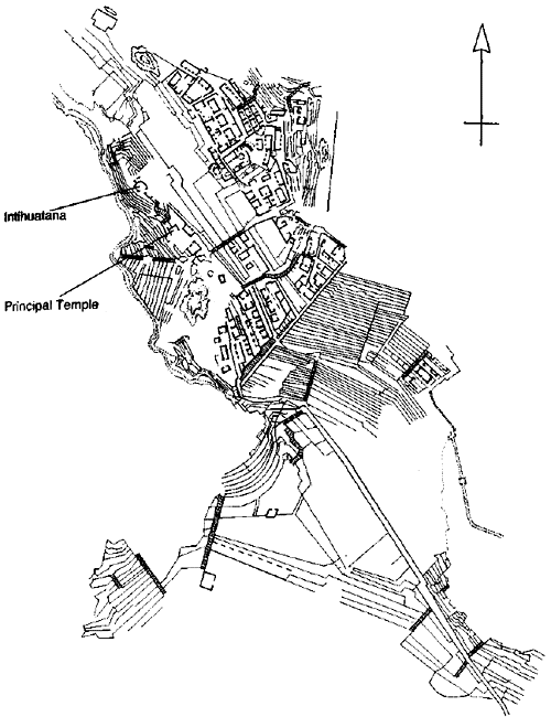
Machu Picchu dreaming
It was two in the afternoon. I stood on a high point at the southern
end of the site. The ruins stretched out northwards in
lichen-enshrouded terraces before me. Thick clouds were wrapped in a
ring around the mountain tops but the sunlight still occasionally
burst through here and there.
Way down on the valley floor I could see the sacred river curled in
a hairpin loop right around the central formation on which
Machu
Picchu was based, like a moat surrounding a giant castle. The river
showed deep green from this vantage point, reflecting the greenness
of the steep jungle slopes. And there were patches of white water
and wonderful sparkling gleams of light.
I gazed across the ruins towards the dominant peak. Its name is
Huayna Picchu and it used to feature in all the classic travel agency
posters of this site. To my astonishment I now observed that for a
hundred meters or so below its summit it had been neatly terraced
and sculpted: somebody had been up there and had carefully raked the
near-vertical cliffs into a graceful hanging garden which had
perhaps in ancient times been planted with bright flowers.
It seemed to me that the entire site, together with its setting, was
a monumental work of sculpture composed in part of mountains, in
part of rock, in part of trees, in part of stones—and also in part
of water. It was a heart-achingly beautiful place, certainly one of
the most beautiful places I have ever seen.
Despite its luminous brilliance, however, I felt that I was gazing
down on to a city of ghosts. It was like the wreck of the Marie
Celeste, deserted and restless. The houses were arranged in long
terraces. Each house was tiny, with just one room fronting directly
on to the narrow street, and the architecture was solid and
functional but by no means ornate.
By way of contrast certain
ceremonial areas were engineered to an infinitely higher standard
and incorporated giant blocks similar to those I had seen at Sacsayhuaman. One smoothly polished polygonal monolith was around
twelve feet long by five feet wide by five feet thick and could not
have weighed less than 200 tons. How had the ancient builders
managed to get it up here?
Machu Picchu.
There were dozens of others like it too, and they were all arranged
in the familiar jigsaw puzzle walls of interlocking angles. On one
block I was able to count a total of thirty-three angles, every one
intermeshed faultlessly with a matching angle on an adjoining block.
There were massive polygons and perfect ashlars with razor-sharp
edges. There were also natural, unhewn boulders integrated into the
overall design at a number of points.
And there were strange and
unusual devices such as the Intihuatana, the ‘hitching post of the
sun’. This remarkable artifact consisted of an elemental chunk of
bedrock, grey and crystalline, carved into a complex geometrical
form of curves and angles, incised niches and external buttresses,
surmounted at the centre by a stubby vertical prong.
Jigsaw puzzle
How old is Machu Picchu? The academic consensus is that the city
could not have been built much earlier than the fifteenth century
AD.9 Dissenting opinions, however, have from time to time been
expressed by a number of more daring but respectable scholars. In
the 1930s, for example, Rolf Muller, professor of Astronomy at the
University of Potsdam, found convincing evidence to suggest that the
most important features of Machu Picchu possessed significant
astronomical alignments.
From these, through the use of detailed
mathematical computations concerning star positions in the sky in
previous millennia (which gradually alter down the epochs as the
result of a phenomenon known as precession of the equinoxes), Muller
concluded that the original layout of the site could only have been
accomplished during ‘the era of 4000 BC to 2000 BC’.10
In terms of orthodox history, this was a heresy of audacious
proportions. If Muller was right, Machu Picchu was not a mere 500
but could be as much as 6000 years old. This would make it
significantly older than the Great Pyramid of Egypt (assuming, of
course, that one accepted the Great Pyramid’s own orthodox dating of
around 2500 BC).
There were other dissenting voices concerning the antiquity of Machu
Picchu, and most, like Muller, were convinced that parts of the site
were thousands of years older than the date favoured by orthodox
historians.11
9 The Ancient Civilizations of Peru, p. 163.
10 Cited in
Zecharia
Sitchin,
The Lost Realms, Avon Books, New York, 1990, p. 164.
11
Another scholar, Maria Schulten de D'Ebneth, also worked with
mathematical methods (as opposed to historical methods which are
heavily speculative and interpretive). Her objective was to
rediscover the ancient grid used to determine Machu Picchu's layout
in relation to the cardinal points. She did this after first
establishing the existence of a central 45° line. In the process she
stumbled across something else: ‘The sub-angles that she calculated
between the central 45° line and sites located away from it ...
indicated to her that the earth's tilt ("obliquity") at the time
this grid was laid out was close to 24° 0’. This means that the grid
was planned (according to her) 5125 years before her measurements
were done in 1953; in other words in 3172 BC.’ The Lost Realms, pp.
204-5.
Like the big polygonal blocks that made up the walls, this was a
notion
that looked as though it might fit with other pieces of a jigsaw
puzzle—in this case the jigsaw puzzle of a past that didn’t quite
make sense any more. Viracocha was part of that same puzzle. All the
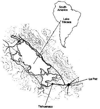
legends said his capital had been at Tiahuanaco. The ruins of this
great and ancient city lay across the border in Bolivia, in an area
known as the Collao, twelve miles south of Lake Titicaca.
We could get there, I calculated, in a couple of days, via Lima and
La Paz.
Back to
Contents
Chapter 8 -
The Lake at the Roof of the World
La Paz, the capital city of Bolivia, nestles in the uneven bottom of
a spectacular hole in the ground more than two miles above sea
level. This plunging ravine, thousands of feet deep, was carved in
some primeval age by a tremendous downrush of water that carried
with it an abrasive tide of loose rocks and rubble.
Provided by nature with such an apocalyptic setting, La Paz
possesses a unique though slightly sleazy charm. With its narrow
streets, dark-walled tenements, imposing cathedrals, garish cinemas
and hamburger bars open till late, it generates an atmosphere of
quirky intrigue which is oddly intoxicating. It’s hard going for the
pedestrian, however, unless equipped with lungs like bellows,
because the whole of the central district is built up and down the
sides of precipitous hills.
La Paz airport is almost 5000 feet higher than the city itself on
the edge of the Altiplano—the cold, rolling uplands that are the
dominant topographical feature of this region. Santha and I landed
there well after midnight on a delayed flight from Lima. In the
draughty arrivals hall we were offered coca tea in little plastic
cups as a prophylactic against altitude sickness.
After considerable
delay and exertion, we extracted our luggage from customs, hailed an
ancient American-made taxi, and clanked and rattled down towards the
dim yellow lights of the city far below.
Lake Titicaca.
Rumours of a cataclysm
Around four o’clock the next afternoon we set off for Lake Titicaca
in a rented jeep, fought our way through the capital’s
incomprehensible permanent rush-hour traffic-jams, then drove up out
of the skyscrapers and slums into the wide, clear horizons of the Altiplano.
At first, still close to the city, our route took us through a zone
of bleak suburbs and sprawling shantytowns where the sidewalks were
lined with auto-repair shops and scrap yards. The more distance we
put between ourselves and La Paz, however, the more attenuated the
settlements became, until almost all signs of human habitation
ceased.
The empty, treeless, undulating savannahs, distantly
bordered by the snow-covered peaks of the Cordillera Real, created
an unforgettable spectacle of natural beauty and power. But there
was also a feeling of otherworldliness about this place, which
seemed to float above the clouds like an enchanted kingdom.
Although our ultimate destination was Tiahuanaco, we were aiming
that night for the town of Copacabana on a promontory near the
southern end of Lake Titicaca. To reach it we had to cross a neck of
water by improvised car ferry at the fishing town of Tiquine. Then,
with dusk descending, we followed the main highway, now little more
than a narrow and uneven track, up a series of steep hairpin bends
and on to the shoulder of a mountain spur.
From this point a
contrasting panorama unfolded: the dark, dark waters of the lake
below appeared to lie at the edge of a limitless ocean drowned in sombre shadows, and yet the jagged peaks of the snowcapped mountains
in the distance were still drenched in dazzling sunlight.
From the very beginning Lake Titicaca seemed to me a special place.
I knew that it lay some 12,500 feet above sea level, that the
frontier between Peru and Bolivia passed through it, that it covered
an area of 3200 square miles and was 138 miles long by about 70
miles wide. I also knew it was deep, reaching almost 1000 feet in
places, and had a puzzling geological history.
Here are the mysteries, and some of the solutions that have been
proposed:
1 - Though now more than two miles above sea level, the area around
Lake Titicaca is littered with millions upon millions of fossilized
sea shells. This suggests that at some stage the whole of the Altiplano was forced upwards from the sea-bed, perhaps as part of
the general terrestrial rising that formed South America as a whole.
In the process great quantities of ocean water, together with
countless myriads of living marine creatures, were scooped up and
suspended among the Andean ranges.1 This is thought to have happened
not more recently than about 100 million years ago.2
2 - Paradoxically, despite the mighty antiquity of this event, Lake
Titicaca has retained, until the present day, ‘a marine
icthyofauna’3, in other words, though now located hundreds of miles
from any ocean, its fish and crustacea feature many oceanic (rather
than freshwater) types. Surprising creatures brought to the surface
in fishermen’s nets have
included examples of Hippocampus (the seahorse).4
In addition, as
one authority has pointed out,
‘The various species of Allorquestes
(hyalella inermis, etc.) and other examples of marine fauna leave no
doubt that this lake in other periods was much saltier than today,
or, more accurately, that the water which formed it was from the sea
and that it was damned up and locked in the Andes when the continent
rose.’5
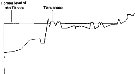
3 - So much, then, for the events which may have created Lake Titicaca
in the first place. Since its formation this great ‘interior sea’,
and the Altiplano itself, has undergone several other drastic and
dramatic changes. Of these by far the most notable is that the
lake’s extent appears to have fluctuated enormously, indicated by
the existence of an ancient strandline visible on much of the
surrounding terrain. Puzzlingly, this strandline is not level but
slopes markedly from north to south over a considerable horizontal
distance.
At the northernmost point surveyed it is as much as 295
feet higher than Titicaca; some 400 miles farther south, it is 274
feet lower than the present level of the lake.6 From this, and much
other evidence, geologists have deduced that the Altiplano is still
gradually rising, but in an unbalanced manner with greater altitudes
being attained in the northern part and lesser in the southern. The
process involved here is thought to have less to do with changes in
the level of Titicaca’s waters themselves (although such changes
have certainly occurred) than with changes in the level of the whole
terrain in which the lake is situated.7
4 - Much harder to explain in such terms, however, given the very long
time periods major geological transformations are supposed to
require, is irrefutable evidence that the city of Tiahuanaco was
once a port, complete with extensive docks, positioned right on the
shore of Lake Titicaca.8 The problem is that Tiahuanaco’s ruins are
now marooned about twelve miles south of the lake and more than 100
feet higher than the present shoreline.9 In the period since the
city was built, it therefore follows that one of two things must
have happened: either the level of lake has fallen greatly or the
land on which Tiahuanaco stands has risen comparably.
5 - Either way it is obvious that there have been massive and
traumatic
physical changes. Some of these, such as the rise of the Altiplano
from the floor of the ocean, certainly took place in remote
geological ages, before the advent of human civilization. Others are
not nearly so ancient and must have occurred after the construction
of Tiahuanaco.10 The question, therefore, is this: when was Tiahuanaco built?
The orthodox historical view is that the ruins cannot possibly be
dated much earlier than AD 500.11 An alternative chronology also
exists, however, which, although not accepted by the majority of
scholars, seems more in tune with the scale of the geological
upheavals that have occurred in this region. Based on the
mathematical/astronomical calculations of Professor Arthur Posnansky
of the University of La Paz, and of Professor Rolf Muller (who also
challenged the official dating of Machu Picchu), it pushes the main
phase of construction at Tiahuanaco back to 15,000 BC.
This
chronology also indicates that the city later suffered immense
destruction in a phenomenal natural catastrophe around the eleventh
millennium BC, and thereafter rapidly became separated from the
lakeshore.12
1
Professor Arthur Posnansky,
Tiahuanacu: The Cradle of American Man,
Ministry of Education, La Paz, Bolivia, 1957, volume III p. 192. See
also Immanuel Velikovsky, Earth in Upheaval, Pocket Books, New York,
1977, pp. 77-8: ‘Investigation into the topography of the Andes and
the fauna of Lake Titicaca, together with a chemical analysis of
this lake and others on the same plateau, has established that the
plateau was at one time at sea level, 12,500 feet lower than it is
today ... and that its lakes were originally part of a sea-gulf ...
Sometime in the past the entire Altiplano, with its lakes, rose from
the bottom of the ocean ...’
2
Personal communication with Richard Ellison of the British
Geological Survey, 17 September 1993. Ellison is the author of the
BGS Overseas Geology and Mineral Resources Paper (No. 65) entitled
The Geology of the Western Corriera and Altiplano.
3 Tiahuanacu,
III, p. 192.
4 Tiahuanacu, J. J. Augustin, New York, 1945, volume I, p. 28.
5
Ibid.
6
See, for example, H.S. Bellamy, Built Before the Flood: The Problem
of the Tiahuanaco
Ruins, Faber & Faber, London, 1943, p. 57.
7 Ibid., p. 59.
8
Tiahuanacu, III, pp. 192-6. See also Bolivia, Lonely Planet
Publications, Hawthorne, Australia, 1992, p. 156.
9
Ibid. See also Harold Osborne, Indians of the Andes: Aymaras and
Quechuas, Routledge and Kegan Paul, London, 1952, p. 55.
10 Earth In Upheaval, p. 76: ‘The conservative view among
evolutionists and geologists is that mountain-making is a slow
process, observable in minute changes, and that because it is a
continuous process there never could have been spontaneous upliftings on a large scale. In the case of Tiahuanaco, however, the
change in altitude apparently occurred after the city was built, and
this could not have been the result of a slow process ...’
11
See, for example, Ian Cameron, Kingdom of the Sun God: A History of
the Andes and Their People, Guild Publishing, London, 1990, pp.
48-9.
12 Tiahuanacu II, p. 91 and I, p. 39.
We shall be reviewing Posnansky’s and
Muller’s findings in Chapter
Eleven, findings which suggest that the great Andean city of Tiahuanaco flourished during the last Ice Age in the deep, dark,
moonless midnight of prehistory.
Back to
Contents
Chapter 9 -
Once and Future King
During my travels in the Andes I had several times re-read a curious
variant of the mainstream tradition of Viracocha. In this variant,
which was from the area around Lake Titicaca known as the Collao,
the deity civilizing-hero had been named Thunupa:
Thunupa appeared on the Altiplano in ancient times, coming from the
north with five disciples. A white man of august presence,
blue-eyed, and bearded, he was sober, puritanical and preached
against drunkenness, polygamy and war.1
After travelling great distances through the Andes, where he created
a peaceful kingdom and taught men all the arts of civilization,2 Thunupa was struck down and grievously wounded by a group of jealous
conspirators:
They put his blessed body in a boat of totora rush and set it adrift
on Lake Titicaca. There ... he sailed away with such speed that
those who had tried so cruelly to kill him were left behind in
terror and astonishment—for this lake has no current ...
The boat
came to the shore at Cochamarca, where today is the river
Desaguadero. Indian tradition asserts that the boat struck the land
with such force it created the river Desaguadero, which before then
did not exist. And on the water so released the holy body was
carried many leagues away to the sea coast at Africa
3
...
1 South American Mythology, p. 87.
2 Ibid., p. 44.
3
Antonio de la Calancha, Cronica Moralizada del Orden de San Augustin
en el Peru, 1638, in South American Mythology, p. 87.
Boats, water and salvation
There are curious parallels here to the story of Osiris, the ancient
Egyptian high god of death and resurrection. The fullest account of
the original myth defining this mysterious figure is given by
Plutarch4 and says that, after bringing the gifts of civilization to
his people, teaching them all manner of useful skills, abolishing
cannibalism and human sacrifice, and providing them with their first
legal code, Osiris left Egypt and travelled about the world to
spread the benefits of civilization to other nations as well.
He
never forced the barbarians he encountered to accept his laws,
preferring instead to argue with them and to appeal to their reason.
It is also recorded that he passed on his teachings to them
by means of hymns and songs accompanied by musical instruments.
4
Good summaries of the Plutarch account are given in M. V.
Seton-Williams, Egyptian Legends and Stories, Rubicon Press, London,
1990, pp. 24-9; and in E. A. Wallis Budge, From Fetish to God in
Ancient Egypt, Oxford University Press, 1934, pp. 178-83.
While he was gone, however, he was plotted against by seventy-two
members of his court, led by his brother-in-law Set. On his return
the conspirators invited him to a banquet where a splendid coffer of
wood and gold was offered as a prize to any guest who could fit into
it exactly. Osiris did not know that the coffer had been constructed
precisely to his body measurements.
As a result, when the assembled
guests tried one by one to get into it they failed. Osiris lay down
comfortably inside. Before he had time to get out the conspirators
rushed forward, nailed the lid tightly closed and sealed even the
cracks with molten lead so that there would be no air. The coffer
was then thrown into the Nile. It had been intended that it should
sink, but it floated rapidly away, drifting for a considerable
distance until it reached the sea coast.
At this point the goddess Isis, wife of Osiris, intervened. Using
all the great magic for which she was renowned, she found the coffer
and concealed it in a secret place. However, her evil brother Set,
out hunting in the marshes, discovered the coffer, opened it and, in
a mad fury, cut the royal corpse into fourteen pieces which he
scattered throughout the land.
Once more Isis set off to save her husband. She made a small boat of
papyrus reeds, coated with pitch, and embarked on the Nile in search
of the remains. When she had found them she worked powerful spells
to reunite the dismembered parts of the body so that it resumed its
old form. Thereafter, in an intact and perfect state, Osiris went
through a process of stellar rebirth to become god of the dead and
king of the underworld—from which place, legend had it, he
occasionally returned to earth in the guise of a mortal man.5
5 From Fetish to God in Ancient Egypt, p. 180.
Although there are huge differences between the traditions it is
bizarre that Osiris in Egypt and Thunupa-Viracocha in South America
should have had all of the following points in common:
-
both were great civilizers
-
both were conspired against
-
both were struck down
-
both were sealed inside a
container or vessel of some kind
-
both were then cast into water
-
both drifted away on a river
-
both eventually reached the sea
Are such parallels to be dismissed as coincidences? or could there
be some underlying connection?
Reed boats of Suriqui
The air was Alpine cold and I was sitting on the front of a motor
launch doing about twenty knots across the icy waters of Lake
Titicaca. The sky above was clear blue, reflecting aquamarine and
turquoise tints inshore, and the vast body of the lake, glinting in
copper and silver tones, seemed to stretch away for ever ...
The passages in the legends that spoke of vessels made of reeds
needed to be followed up because I knew that ‘boats of totora rush’
were a traditional form of transport on this lake. However, the
ancient skills required to build craft of this type had atrophied in
recent years and we were now headed towards Suriqui, the one place
where they were still properly made.
On Suriqui Island, in a small village close to the lakeshore, I
found two elderly Indians making a boat from bundled totora rushes.
The elegant craft, which appeared to be nearly complete, was
approximately fifteen feet long. It was wide amidships, but narrow
at either end with a high curving prow and stern.
I sat down for a while to watch. The more senior of the two
builders, who wore a brown felt hat over a curious peaked woollen
cap, repeatedly braced his bare left foot against the side of the
vessel to give additional leverage as he pulled and tightened the
cords that held the bundles of reeds in place. From time to time I
noticed that he rubbed a length of cord against his own perspiring
brow—thus moistening it to increase its adhesion.
The boat, surrounded by chickens and occasionally investigated by a
shy, browsing alpaca, stood amid a litter of discarded rushes in the
backyard of a ramshackle farmhouse. It was one of several I was able
to study over the next few hours and, though the setting was
unmistakably Andean, I found myself repeatedly overtaken by a sense
of déjà vu from another place and another time.
The reason was that
the totora vessels of Suriqui were virtually identical, both in the
method of construction and in finished appearance, to the beautiful
craft fashioned from papyrus reeds in which the Pharaohs had sailed
the Nile thousands of years previously. In my travels in Egypt I had
examined the images of many such vessels painted on the walls of
ancient tombs. It sent a tingle down my spine to see them now so
colourfully brought to life on an obscure island on Lake
Titicaca—even though my research had partially prepared me for this
coincidence.
I knew that no satisfactory explanation had ever been
given for how such close and richly detailed similarities of boat
design could occur in two such widely separated places.
Nevertheless, in the words of one authority in ancient navigation
who had addressed himself to this conundrum:
Here was the same compact shape, peaked and raised at both ends with
rope lashings running from the deck right round the bottom of the
boat all in one piece ... Each straw was placed with maximum
precision to achieve perfect symmetry and streamlined elegance,
while the bundles were so tightly lashed that they looked like ...
gilded logs bent into a clog-shaped peak fore and aft.6
The reed boats of the ancient Nile, and the reed boats of Lake
Titicaca (the original design of which, local Indians insisted, had
been given to them by ‘the Viracocha people’7), had other points in
common. Both, for example, were equipped with sails mounted on
peculiar two-legged straddled masts.8 Both had also been used for
the long-distance transport of exceptionally heavy building
materials: obelisks and gargantuan blocks of stone bound for the
temples at Giza and Luxor and Abydos on the one hand and for the
mysterious edifices of Tiahuanaco on the other.
6 Thor Heyerdahl, The Ra Expeditions, Book Club Associates, London,
1972, pp. 43, 295.
7 Ibid., p. 43.
8 Ibid., p. 295.
In those far-off days, before Lake Titicaca became more than one
hundred feet shallower,
Tiahuanaco had stood at the water’s edge
overlooking a vista of awesome and sacred beauty. Now the great
port, capital city of Viracocha himself, lay lost amid eroded hills
and empty windswept plains.
Road to Tiahuanaco ...
After returning from Suriqui to the mainland we drove our hired jeep
across those plains, raising a cloud of dust. Our route took us
through the towns of Puccarani and Laha, populated by stolid Aymara
Indians who walked slowly in the narrow cobbled streets and sat
placidly in the little sunlit plazas.
Were these people the descendants of the builders of Tiahuanaco, as
the scholars insisted? Or were the legends right? Had the ancient
city been the work of foreigners with godlike powers who had settled
here, long ages ago?
Back to
Contents
Chapter 10 -
The City at the Gate of the Sun
The early Spanish travellers who visited the ruined Bolivian city of
Tiahuanaco at around the time of the conquest were impressed by the
sheer size of its buildings and by the atmosphere of mystery that
clung to them.
‘I asked the natives whether these edifices were
built in the time of the Inca,’ wrote the chronicler Pedro Cieza de
Leon, ‘They laughed at the question, affirming that they were made
long before the Inca reign and ... that they had heard from their
forebears that everything to be seen there appeared suddenly in the
course of a single night ...’1
Meanwhile another Spanish visitor of
the same period recorded a tradition which said that the stones had
been lifted miraculously off the ground,
‘They were carried through
the air to the sound of a trumpet.’2
Not long after the conquest a detailed description of the city was
written by the historian Garcilaso de la Vega. No looting for
treasure or for building materials had yet taken place and, though
ravaged by the tooth of time, the site was still magnificent enough
to take his breath away:
We must now say something about the large and almost incredible
buildings of Tiahuanaco. There is an artificial hill, of great
height, built on stone foundations so that the earth will not slide.
There are gigantic figures carved in stone ... these are much worn
which shows their great antiquity. There are walls, the stones of
which are so enormous it is difficult to imagine what human force
could have put them in place.
And there are the remains of strange
buildings, the most remarkable being stone portals, hewn out of
solid rock; these stand on bases anything up to 30 feet long, 15
feet wide and 6 feet thick, base and portal being all of one piece
... How, and with the use of what tools or implements, massive works
of such size could be achieved are questions which we are unable to
answer ... Nor can it be imagined how such enormous stones could
have been brought here ...3
1
Pedro Cieza de Leon, Chronicle of Peru, Hakluyt Society, London,
1864 and 1883, Part I, Chapter 87.
2
Indians of the Andes: Aymaras and Quechuas, p. 64. See also Feats
and Wisdom of the Ancients, Time-Life Books, Alexandria, Virginia,
1990, p. 55.
3
Royal Commentaries of the Incas, Book Three, Chapter one. See, for
example, version published by Orion Press, New York, 1961
(translated by Maria Jolas from the critical annotated French
edition of Alain Gheerbrant), pp. 49-50.
Tiahuanaco.
That was in the sixteenth century. More than 400 years later, at the
end of the twentieth century, I shared Garcilaso’s puzzlement.
Scattered around Tiahuanaco, in defiance of the looters who had
robbed the site of so much in recent years, were monoliths so big
and cumbersome yet so well cut that they almost seemed to be the
work of super-beings.
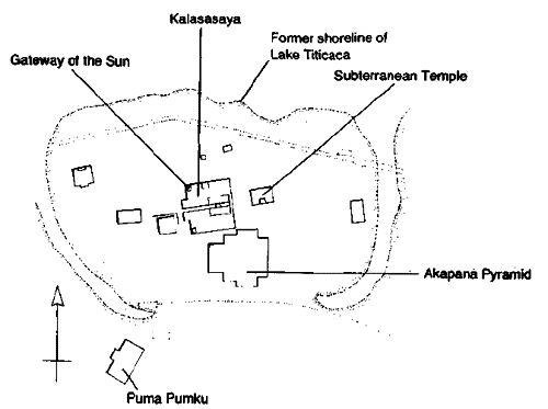
Sunken temple
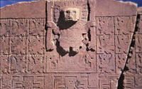
Like a disciple at the feet of his master, I sat on the floor of the
sunken temple and looked up at the enigmatic face which all the
scholars of Tiahuanaco believed was intended to represent Viracocha.
Untold centuries ago, unknown hands had carved this likeness into a
tall pillar of red rock. Though now much eroded, it was the likeness
of a man at peace with himself. It was the likeness of a man of
power ...
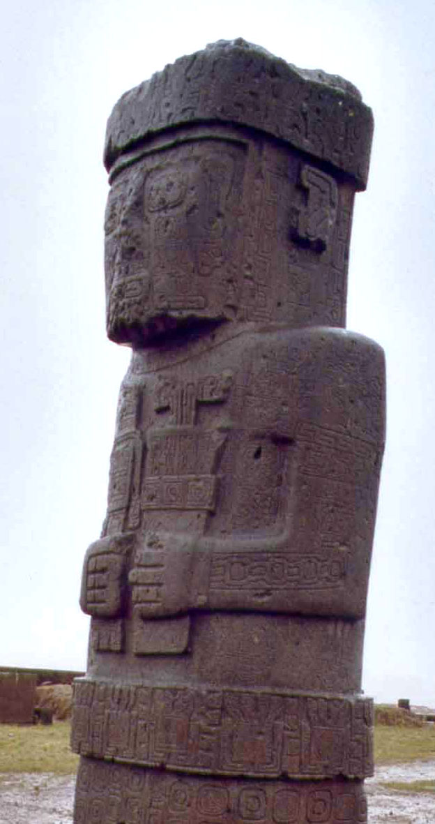
He had a high forehead, and large, round eyes. His nose was
straight, narrow at the bridge but flaring towards the nostrils. His
lips were full. His distinguishing feature, however, was his stylish
and imposing beard, which had the effect of making his face broader
at the jaws than at the temples. Looking more closely, I could see
that the sculptor had portrayed a man whose skin was shaved all
around his lips with the result that his moustache began high on his
cheeks, roughly parallel with the end of his nose. From there it
curved extravagantly down beside the corners of his mouth, forming
an exaggerated goatee at the chin, and then followed his jawline
back to his ears.
Above and below the ears, on the side of the head, were carved odd
representations of animals. Or perhaps it would be better to
describe these carvings as representations of odd animals, because
they looked like big, clumsy, prehistoric mammals with fat tails and
club feet.
There were other points of interest. For example, the stone figure
of Viracocha had been sculpted with the hands and arms folded, one
below the other, over the front of a long, flowing robe. On each
side of this robe appeared the sinuous form of a snake coiling
upwards from ground to shoulder level. And as I looked at this
beautiful design (the original of which had perhaps been embroidered
on rich cloth) the picture that came into my mind was of Viracocha
as a wizard or a sorcerer, a bearded, Merlin-like figure dressed in
weird and wonderful clothes, calling down fire from heaven.
The ‘temple’ in which the Viracocha pillar stood was open to the sky
and consisted of a large, rectangular pit, like a swimming pool, dug
out six feet below ground level. Its floor, about 40 feet long by 30
feet wide, was composed of hard, flat gravel. Its strong vertical
walls were formed from precisely dressed ashlar blocks of varying
sizes laid closely against one another without mortar in the joints
and interspersed with taller, rough-hewn stelae. A set of steps was
let into the southern wall and it was down these I had come when I
had entered the structure.
I walked several times around the figure of Viracocha, resting my
fingers on the sun-warmed stone pillar, trying to guess its purpose.
It was perhaps seven feet tall and it faced south, with its back to
the old shoreline of Lake Titicaca (originally less than six hundred
feet away).4 Ranged out behind this central obelisk, furthermore,
there were two others, of smaller stature, possibly intended to
represent Viracocha’s legendary companions. All three figures, being
severely, functionally vertical, cast clean-edged shadows as I gazed
at them, for the sun was past its zenith.
4 Bolivia, p. 156 (map).
I sat down on the ground again and looked slowly all around the
temple. Viracocha dominated it, like the conductor of an orchestra,
and yet its most striking feature undoubtedly lay elsewhere: lining
the walls, at various points and heights, were dozens and dozens of
human heads sculpted in stone. These were complete heads, protruding
three dimensionally out of the walls. There were several different
(and contradictory) scholarly opinions as to their function.
Pyramid
From the floor of the sunken temple, looking west, I could see an
immense wall into which was set an impressive geometrical gateway
made of large stone slabs. Silhouetted in this gateway by the
afternoon sun was the figure of a giant. The wall, I knew, enclosed
a parade-ground
sized area called the Kalasasaya (a word in the local Aymara
language meaning simply ‘Place of the Upright Standing Stones’5).
And the giant was one of the huge time-worn pieces of sculpture
referred to by Garcilaso de la Vega.
I was eager to take a look at it, but for the moment my attention
was diverted southwards towards an artificial hill, 50 feet high,
which lay almost directly ahead of me as I climbed the steps out of
the sunken temple. The hill, which had also been mentioned by
Garcilaso, was known as the Akapana Pyramid. Like the pyramids at Giza in Egypt, it was oriented with surprising precision towards the
cardinal points. Unlike those pyramids its ground-plan was somewhat
irregular. Nonetheless, it measured roughly 690 feet on each side
which meant that it was a hulking piece of architecture and the
dominant edifice of Tiahuanaco.
I walked towards it now, and spent some time strolling around it and
clambering over it. Originally it had been a clean-sided
step-pyramid of earth faced with large andesite blocks. In the
centuries since the conquest, however, it had been used as a quarry
by builders from as far away as La Paz, with the result that only
about ten per cent of its superb facing blocks now remained.
What clues, what evidence, had those nameless thieves carried off
with them? As I climbed up the broken sides and around the deep
grassy troughs in the top of the Akapana, I realized that the true
function of the pyramid was probably never going to be understood.
All that was certain was that it had not been merely decorative or
ceremonial. On the contrary, it seemed almost as though it might
have functioned as some kind of arcane ‘device’ or machine.
Deep
within its bowels, archaeologists had discovered a complex network
of zig-zagging stone channels, lined with fine ashlars. These had
been meticulously angled and jointed (to a tolerance of one-fiftieth
of an inch), and had served to sluice water down from a large
reservoir at the top of the structure, through a series of
descending levels, to a moat that encircled the entire site, washing
against the pyramid’s base on its southern side.6
5
H. S. Bellamy and P. Allan, The Calendar of Tiahuanaco: The
Measuring System of the Oldest Civilization, Faber & Faber, London,
1956, p. 16.
6
For a detailed discussion of the hydraulic system of the Akapana see
Tiahuanacu: II, pp. 69-79.
So much care and attention had been lavished on all this plumbing,
so many man-hours of highly skilled and patient labour, that the
Akapana made no sense unless it had been endowed with a significant
purpose. A number of archaeologists, I knew, had speculated that
this purpose might have been connected with a rain or river cult
involving a primitive veneration of the powers and attributes of
fast-flowing water.
One sinister suggestion, which implied that the unknown ‘technology’
of the pyramid might have had a lethal purpose, was derived from the
meaning of the words Hake and Apana in the ancient Aymara language
still spoken hereabouts:
‘Hake means “people” or “men”; Apana means
“to perish” (probably by water). Thus Akapana is a place where
people perish ...’7
Another commentator, however, after making a careful assessment of
all the characteristics of the hydraulic system, proposed a
different solution, namely that the sluices had most probably been
part of ‘a processing technique—the use of flowing water for washing
ores, perhaps?’8
7 Ibid., I, p. 78.
8 The Lost Realms, p. 215. 9 Tiahuanacu, II, pp. 44-105. 10 The
Calendar of Tiahuanaco, pp. 17-18.
Gateway of the Sun
Leaving the western side of the enigmatic pyramid, I made my way
towards the south-west corner of the enclosure known as the
Kalassaya. I could now see why it had been called the Place of the
Upright Standing Stones for this was precisely what it was. At
regular intervals in a wall composed of bulky trapezoidal blocks,
huge dagger-like monoliths more than twelve feet high had been sunk
hilt-first into the red earth of the Altiplano. The effect was of a
giant stockade, almost 500 feet square, rising about twice as far
above the ground as the sunken temple had been interred beneath it.
Had the Kalasasaya been a fortress then? Apparently not. Scholars
now generally accept that it functioned as a sophisticated celestial
observatory. Rather than keeping enemies at bay, its purpose had
been to fix the equinoxes and the solstices and to predict, with
mathematical precision, the various seasons of the year.
Certain
structures within its walls, (and, indeed, the walls themselves),
appeared to have been lined up to particular star groups and
designed to facilitate measurement of the amplitude of the sun in
summer, winter, autumn and spring.9 In addition, the famous ‘Gateway
of the Sun’, which stood in the north-west corner of the enclosure,
was not only a world-class work of art but was thought by those who
had studied it to be a complex and accurate calendar carved in
stone:
The more one gets acquainted with the sculpture the greater becomes
one’s conviction that the peculiar lay-out and pictorialism of this
Calendar cannot possibly have been the result merely of the
ultimately unfathomable whim of an artist, but that its glyphs,
deeply senseful, constitute the eloquent record of the observations
and calculations of a scientist ... The Calendar could not have been
drawn up and laid out in any other way than this.10
My background research had made me especially curious about the
Gateway of the Sun and, indeed, about the Kalasasaya as a whole.
This
was so because certain astronomical and solar alignments which we
review in the next chapter had made it possible to calculate the
approximate period when the Kalasasaya must originally have been
laid out. These alignments suggested the controversial date of
15,000 BC— about seventeen thousand years ago.
Back to
Contents
Chapter 11 -
Intimations of Antiquity
In his voluminous work
Tiahuanacu: the Cradle of American Man, the
late Professor Arthur Posnansky (a formidable German-Bolivian
scholar whose investigations at the ruins lasted for almost fifty
years) explains the archaeo-astronomical calculations which led to
his controversial re-dating of Tiahuanaco. These, he says, were
based ‘solely and exclusively on the difference in the obliquity of
the ecliptic of the period in which the Kalasasaya was built and
that which it is today’.1
What exactly is ‘the obliquity of the ecliptic’, and why does it
make Tiahuanaco 17,000 years old?
According to the dictionary definition it is ‘the angle between the
plane of the earth’s orbit and that of the celestial equator, equal
to approximately 23° 27’ at present’.2
1 Tiahuanacu, II, p. 89.
2
Collins English Dictionary, London, 1982, p. 1015. In addition, Dr
John Mason of the British Astronomical Association defined obliquity
of the ecliptic in a telephone interview on 7 October 1993: ‘The
earth spins about an axis which goes through its centre and its
north and south poles. This axis is inclined to the plane of the
earth's orbit around the sun. This tilt is called the obliquity of
the ecliptic. The current value for the obliquity of the ecliptic is
23.44 degrees.’
To clarify this obscure astronomical notion, it helps to picture the
earth as a ship, sailing on the vast ocean of the heavens. Like all
such vessels (be they planets or schooners), it rolls slightly with
the swell that flows beneath it. Picture yourself on board that ship
as it rolls, standing on the deck, gazing out to sea. You rise up on
the crest of a wave and your visible horizon increases; you fall
back into a trough and it decreases. The process is regular,
mathematical, like the tick-tock of a great metronome: a constant,
almost imperceptible, nodding, perpetually changing the angle
between yourself and the horizon.
Now picture the earth again. Floating in space, as every schoolchild
knows, the axis of daily rotation of our beautiful blue planet lies
slightly tilted away from the vertical in its orbit around the sun.
From this it follows that the terrestrial equator, and hence the
‘celestial equator’ (which is merely an imaginary extension of the
earth’s equator into the celestial sphere) must also lie at an angle
to the orbital plane. That angle, at any one time, is the obliquity
of the ecliptic. But because the earth is a ship that rolls, its
obliquity changes in a cyclical manner over very long periods.
During each cycle of 41,000 years the obliquity varies, with the
precision and predictability of a Swiss chronograph, between 22.1°
and
24.5°.3 The sequence in which one angle will follow another, as well
as the sequence of all previous angles (at any period of history)
can be calculated by means of a few straightforward equations. These
have been expressed as a curve on a graph (originally plotted out in
Paris in 1911 by the International Conference of Ephemerids) and
from this graph it is possible to match angles and precise
historical dates with confidence and accuracy.
Posnansky was able to date the Kalasasaya because the obliquity
cycle gradually alters the azimuth position of sunrise and sunset
from century to century.4 By establishing the solar alignments of
certain key structures that now looked ‘out of true’, he
convincingly demonstrated that the obliquity of the ecliptic at the
time of the building of the Kalasasaya had been 23° 8’ 48”. When
that angle was plotted on the graph drawn up by the International
Conference of Ephemerids it was found to correspond to a date of
15,000 BC.5
Of course, not a single orthodox historian or archaeologist was
prepared to accept such an early origin for Tiahuanaco preferring,
as noted in Chapter Eight, to agree on the safe estimate of AD 500.
During the years 1927-30, however, several scientists from other
disciplines checked carefully Posnansky’s ‘astronomic-archaeological
investigations’.
These scientists, members of a high-powered team
which also studied many other archaeological sites in the Andes,
were Dr Hans Ludendorff (then director of the Astronomical
Observatory of Potsdam), Dr Friedrich Becker of the Specula Vaticanica, and two other astronomers: Professor Dr
Arnold Kohlschutter of the University of Bonn and Dr
Rolf Muller of the
Astrophysical Institute of Potsdam.6
At the end of their three years of work the scientists concluded
that Posnansky was basically right. They didn’t concern themselves
with the implications of their findings for the prevailing paradigm
of history; they simply stated the observable facts about the
astronomical alignments of various structures at Tiahuanaco. Of
these, the most important by far was that the Kalasasaya had been
laid out to conform with observations of the heavens made a very
long time ago—much, much further back than AD
500. Posnansky’s figure of 15,000 BC was pronounced to be well
within the bounds of possibility.7
If Tiahuanaco had indeed flourished so long before the dawn of
history, what sort of people had built it, and for what purpose?
3
J. D. Hays, John Imbrie, N. J. Shackleton, ‘Variations in the
Earth's Orbit: Pacemaker of the Ice Ages’, in Science, vol. 194, No.
4270, 10 December 1976, p. 1125.
4
Anthony F. Aveni, Skywatchers of Ancient Mexico, University of Texas
Press, lago, p.
103.
5 Tiahuanacu, II, p. 90-1.
6 Tiahuanacu, II, p. 47.
7 Ibid., p. 91.
Fish-garbed figures
There were two massive pieces of statuary inside the
Kalasasaya.
One, a figure nicknamed El Fraile (The Friar) stood in the
south-west corner; the other, towards the centre of the eastern end
of the enclosure, was the giant that I had observed from the sunken
temple.
Carved in red sandstone, worn and ancient beyond reckoning, El Fraile stood about six feet high, and portrayed a humanoid,
 androgynous being with massive eyes and lips. In its right hand it
clutched something androgynous being with massive eyes and lips. In its right hand it
clutched something
 resembling a knife with a wavy blade like an
Indonesian kris. In its left hand was an object like a hinged and
case-bound book. From the top of this ‘book’, however, protruded a
device which had been inserted into it as though into a sheath. resembling a knife with a wavy blade like an
Indonesian kris. In its left hand was an object like a hinged and
case-bound book. From the top of this ‘book’, however, protruded a
device which had been inserted into it as though into a sheath.
From the waist down the figure appeared to be clad in a garment of
fish scales, and, as though to confirm this perception, the sculptor
had formed the individual scales out of rows and rows of small,
highly-stylized fish-heads. This sign had been persuasively
interpreted by Posnansky as meaning fish in general.8
It seemed,
therefore, that El Fraile was a portrayal of an imaginary or
symbolic ‘fish man’. The figure was also equipped with a belt
sculpted with the images of several large crustaceans, so this
notion seemed all the more probable. What had been intended?
I had learned of one local tradition I thought might shed light on
the matter. It was very ancient and spoke of ‘gods of the lake, with
fish tails, called Chullua and Umantua’.9 In this, and in the
fish-garbed figures, it seemed that there was a curious out-of-place
echo of Mesopotamian myths, which spoke strangely, and at length,
about amphibious beings, ‘endowed with reason’ who had visited the
land of Sumer in remote prehistory. The leader of these beings was
named Oannes (or Uan).10
According to the Chaldean scribe, Berosus:
The whole body of [Oannes] was like that of a
fish; and had under a
fish’s head another head, and also feet below, similar to those of a
man, subjoined to the fish’s tail. His voice too, and language, was
articulate and human; and a representation of him is preserved even
to this day ... When the sun set, it was the custom of this Being to
plunge again into the sea, and abide all night in the deep; for he
was amphibious.11
8 Ibid., I, p. 119.
9 Ibid., II, p. 183.
10
Myths from Mesopotamia, (trans, and ed. Stephanie Dalley), Oxford
University Press, 1990, p. 326.
11
Fragments of Berossus, from Alexander Polyhistor, reprinted as
Appendix 2 in Robert
K. G. Temple, The Sirius Mystery, Destiny Books, Rochester, Vermont,
1987, pp. 250-1.
According to the traditions reported by Berosus, Oannes was, above
all, a civilizer:
In the day-time he used to converse with men; but took no food at
that season;
and he gave them an insight into letters and sciences, and every
kind of art. He taught them to construct houses, to found temples,
to compile laws, and explained to them the principles of geometrical
knowledge.
He made them distinguish the seeds of the earth, and
showed them how to collect fruits; in short, he instructed them in
every thing which could tend to soften manners and to humanise
mankind. From that time, so universal were his instructions, nothing
has been added materially by way of improvement ...12
Surviving images of the Oannes creatures I had seen on Babylonian
and Assyrian reliefs clearly portrayed fish-garbed men. Fish-scales
formed the dominant motif on their garments, just as they did on
those worn by El Fraile. Another similarity was that the Babylonian
figures held unidentified objects in both their hands. If my memory
served me right (and I later confirmed that it did) these objects
were by no means identical to those carried by El Fraile. They were,
however, similar enough to be worthy of note.13
12 Ibid.
13 Jeremy Black and Anthony Green, Gods, Demons and Symbols of
Ancient Mesopotamia,British Museum Press, 1992, pp. 46, 82-3.
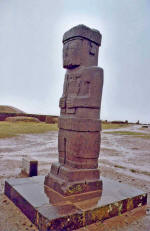
The other great ‘idol’ of the Kalasasaya was positioned towards the
eastern end of the platform, facing the main gateway, and was an
imposing monolith of grey andesite, hugely thick and standing about
nine feet tall. Its broad head rose straight up out of its hulking
shoulders and its slab-like face stared expressionlessly into the
distance. It was wearing a crown, or head-band of some kind, and its
hair was braided into orderly rows of long vertical ringlets which
were most clearly visible at the back.
The figure was also intricately carved and decorated across much of
its surface almost as though it were tattooed. Like El Fraile, it
was clad below the waist in a garment composed offish-scales and
fish symbols. And, also like El Fraile, it held two unidentifiable
objects in its hands. This time the left-hand object looked more
like a sheath than a case-bound book, and from it protruded a forked
handle.
The right-hand object was roughly cylindrical, narrow in the
centre where it was held, wider at the shoulders and at the base,
and then narrowing again towards the top. It appeared to have
several different sections, or parts, fitted over and into one
another, but it was impossible to guess what it might represent.
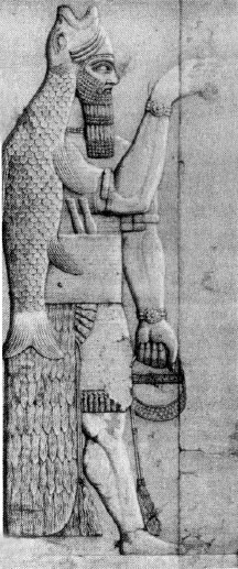
Assyrian relief of fish-garbed figure.
Images of extinct species
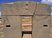
Leaving the fish-garbed figures, I came at last to the
Gateway of
the Sun, located in the north-west corner of the Kalasasaya.
It proved to be a freestanding monolith of grey-green andesite about
12½ feet wide, 10 feet high and 18 inches thick, weighing an
estimated 10 tons.14 Perhaps best envisaged as a sort of
Arc de Triomphe, though on a much smaller scale, it looked in this setting
like a door connecting
two invisible dimensions—a door between nowhere and nothing. The
stonework was of exceptionally high quality and authorities agreed
that it was ‘one of the archaeological wonders of the Americas’.15
Its most enigmatic feature was the so-called ‘calendar frieze’
carved into its eastern façade along the top of the portal.
At its centre, in an elevated position, this frieze was dominated by
what scholars took to be another representation of Viracocha,16 but
this time in his more terrifying aspect as the god-king who could
call down fire from heaven. His gentle, fatherly side was still
expressed: tears of compassion were running down his cheeks. But his
face was set stern and hard, his tiara was regal and imposing, and
in either hand he grasped a thunderbolt.17
In the interpretation
given by Joseph Campbell, one of the twentieth century’s best-known
students of myth,
‘The meaning is that the grace that pours into the
universe through the sun door is the same as the energy of the bolt
that annihilates and is itself indestructible ...’18
I turned my head to right and left, slowly studying the remainder of
the frieze. It was a beautifully balanced piece of sculpture with
three rows of eight figures, twenty-four in all, lined up on either
side of the elevated central image. Many attempts, none of them
particularly convincing, have been made to explain the assumed
calendrical function of these figures.19
All that could really be
said for sure was that they had a peculiar, bloodless, cartoon-like
quality, and that there was something coldly mathematical, almost
machinelike, about the way they seemed to march in regimented lines
towards Viracocha. Some apparently wore bird masks, others had
sharply pointed noses, and each had in his hand an implement of the
type the high god was himself carrying.
The base of the frieze was filled with a design known as the
‘Meander’—a geometrical series of step-pyramid forms set in a
continuous line, and arranged alternately upside down and right side
up, which was also thought to have had a calendrical function. On
the third column from the right-hand side (and, more faintly, on the
third column from the left-hand side too) I could make out a clear
carving of an elephant’s head, ears, tusks and trunk.
This was
unexpected since there are no elephants anywhere in the New World.
There had been, however, in prehistoric times, as I was able to
confirm much later. Particularly numerous in the southern Andes,
until their sudden extinction around 10,000 BC,20 had been the
members of a species called Cuvieronius, an
elephant-like proboscid complete with tusks and a trunk, uncannily
similar in appearance to the ‘elephants’ of the Gateway of the
Sun.21
14 Figures and measurements from The Ancient Civilizations of Peru,
p. 92.
15 Ibid.
16 Ibid.
17
See Joseph Campbell, The Hero with a Thousand Faces, Paladin Books,
London, 1988,
p. 145.
18 Ibid., p. 146.
19
The calendrical function of the Gateway of the Sun is fully
described and analysed by Posnansky in Tiahuanacu: The Cradle of
American Man, volumes I-IV.
20
Quaternary Extinctions: A Prehistoric Revolution, Paul S. Martin,
Richard G. Klein, eds. The University of Arizona Press, 1984, p. 85.
21 Ibid.
I stepped forward a few paces to take a closer look at these
elephants. Each turned out to be composed of the heads of two
crested condors, placed throat to throat (the crests constituting
the ‘ears’ and the upper part of the necks the ‘tusks’). The
creatures thus formed still looked like elephants to me, perhaps
because a characteristic visual trick the sculptors of Tiahuanaco
had employed again and again in their subtle and otherworldly art
had been to use one thing to depict another. Thus an apparently
human ear on an apparently human face might turn out to be a bird’s
wing.
Likewise an ornate crown might be composed of alternate
fishes’ and condors’ heads, an eyebrow a bird’s neck and head, the
toe of a slipper an animal’s head, and so on. Members of the
elephant family formed out of condors’ heads, therefore, need not
necessarily be optical illusions; on the contrary, such inventive
composites would be perfectly in keeping with the overall artistic
character of the frieze.
Among the riot of stylized animal figures carved into the Gateway of
the Sun were a number of other extinct species as well. I knew from
my research that one of these had been convincingly identified by
several observers as Toxodon22—a three-toed amphibious mammal about
nine feet long and five feet high at the shoulder, resembling a
short, stubby cross between a rhino and a hippo.23 L
ike Cuvieronius,
Toxodon had flourished in South America in the late Pliocene (1.6
million years ago) and had died out at the end of the Pleistocene,
about 12,000 years ago.24
22
See The Calendar of Tiahuanaco, p. 47. Posnansky's work is also
replete with references to Toxodon.
23 Encyclopaedia Britannica,
1991, 11:878.
24 Ibid., 9:516. See also Quaternary Extinctions, pp.
64-5.
Top left: Detail from Tiahuanaco’s Gateway of the Sun showing
proboscid, tusked elephant-like figure.
Top right: Biological
reconstruction-drawing of Cuverionius, a South American proboscid,
once common in the Tiahuanaco area but extinct since approximately
10,000 BC.
Above left: Unidentified animal, possibly Toxodon, carved
on the side of the Viracocha figure in the Subterranean Temple.
Above right: Another possible representation of Toxodon from
Tiahuanaco.
The raised nostrils are indicative of a semi-aquatic
animal,
somewhat like a modern hippopotamus in its habits, which is
what Toxodon is known to have been.
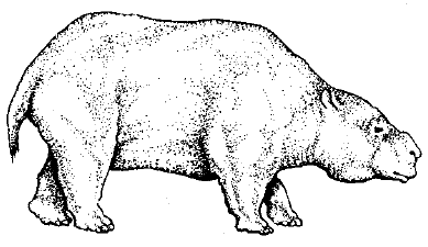
Reconstruction-drawing of Toxodon, a South American species that
became extinct in the eleventh millennium BC.
To my eye this looked like striking corroboration for the
astroarchaeological evidence that dated Tiahuanaco to the end of the
Pleistocene, and further undermined the orthodox historical
chronology which made the city only 1500 years old, since Toxodon,
presumably, could only have been modelled from life. It was
therefore obviously a matter of some importance that no fewer that
forty-six Toxodon heads had been carved into the frieze of the
Gateway of the Sun.25
25 The Calendar of Tiahuanaco, pp. 47-8.
Nor was this
creature’s ugly caricature confined only to the Gateway. On the
contrary, Toxodon had been identified on numerous fragments of
Tiahuanacan pottery. Even more convincingly, he had been portrayed
in several pieces of sculpture which showed him in full
three-dimensional glory.26 Moreover representations of other extinct
species had been found: the species included Shelidoterium, a
diurnal quadruped, and Macrauchenia, an animal somewhat larger than
the modern horse, with distinctive three-toed feet.27
Such images meant that Tiahuanaco was a kind of picture-book from
the past, a record of bizarre animals, now deader than the dodo,
expressed in everlasting stone.
But the record-taking had come to an abrupt halt one day and
darkness had descended. This, too, was recorded in stone—the Gateway
of the Sun, that surpassing work of art, had never been completed.
Certain unfinished aspects of the frieze made it seem probable that
something sudden and dreadful had happened which had caused the
sculptor, in the words of Posnansky, ‘to drop his chisel for ever’
at the moment when he was ‘putting the final touches to his work’.28
26 Tiahuanacu, III, p. 57, 133-4, and plate XCII.
27 Ibid., I, pp.
137-9; Quaternary Extinctions, pp. 64-5.
28 Tiahuanacu, II, p. 4.
Back to
Contents
Chapter 12 -
The End of the Viracochas
We saw in Chapter Ten that Tiahuanaco was originally built as a port
on the shores of Lake Titicaca, when that lake was far wider and
more than 100 feet deeper than it is today. Vast harbour
constructions, piers and dykes (and even dumped cargoes of quarried
stone at points beneath the old waterline), leave no doubt that this
must have been the case.1
Indeed, according to the unorthodox
estimates of Professor Posnansky, Tiahuanaco had been in active use
as a port as early as 15,000 BC, the date he proposed for the
construction of the Kalasasaya, and had continued to serve as such
for approximately another five thousand years, during which great
expanse of time its position in relation to the shore of Lake
Titicaca hardly changed.2
Throughout this epoch the principal harbour of the port city was
located several hundred meters south-west of the Kalasasaya at a
site now known as Puma Punku (literally, the Puma Gate). Here Posnansky’s excavations revealed two artificially dredged docks on
either side of:
‘a true and magnificent pier or wharf ... where
hundreds of ships could at the same time take on and unload their
heavy burdens’.3
One of the construction blocks from which the pier had been
fashioned still lay on site and weighed an estimated 440 tons.4
Numerous others weighed between 100 and 150 tons.5 Furthermore, many
of the biggest monoliths had clearly been joined to each other by
I-shaped metal clamps. In the whole of South America, I knew, this
masonry technique had been found only on Tiahuanacan structures.6
The last time I had seen the characteristic notched depressions
which proved its use had been on ruins on the island of Elephantine
in the Nile in Upper Egypt.7
1 Tiahuanacu, II, p. 156ff; III, p. 196.
2
Ibid., I, p. 39: ‘An extensive series of canals and hydraulic works,
dry at present, but which are all in communication with the former
lake bed, are just so many more proofs of the extension of the lake
as far as Tiahuanacu in this period.’
3 Ibid., II, p. 156.
4
Bolivia, p. 158.
5 The Ancient Civilizations of Peru, p. 93.
6 Ibid.
7
For example on the paving blocks above the Nilometer at Elepantine
Island, Aswan. I am indebted to US film maker Robert Gardner for
pointing this similarity out to me.
12,000 years ago, when Lake Titicaca was more than 100 feet deeper
than it is today,
Tiahuanaco would have been an island, as shown
above.
Equally thought-provoking was the appearance of the symbol of the
cross on many of these ancient blocks. Recurring again and again,
particularly at the northern approach to Puma Punku, this symbol
always took the same form: a double crucifix with pure clean lines,
perfectly balanced and harmonious, deeply recessed into the hard
grey stone.
Even according to orthodox historical chronology these
crosses were not less than 1500 years old. In other words, they had
been carved here, by a people with absolutely no knowledge of
Christianity, a full millennium before the arrival of the first
Spanish missionaries on the Altiplano.
Where, come to that, had the Christians obtained their crosses? Not
only from the shape of the structure to which Jesus Christ was
nailed, I thought, but from some much older source as well. Hadn’t
the Ancient Egyptians, for example, used a hieroglyph very like a
cross (the ankh, or crux ansata) to symbolize life ... the breath of
life ... eternal life itself?8 Had that symbol originated in Egypt,
or had it perhaps occurred elsewhere, earlier still?
8
The Encyclopedia of Ancient Egypt ed. Margaret Burson, Facts on
File, New York and Oxford, 1991, p. 23.
With such ideas chasing one another around my head, I walked slowly
around Puma Punku. The extensive perimeter, which formed a rectangle
several hundred feet long, outlined a low pyramidal hill, much
overgrown with tall grass. Dozens and dozens of hulking blocks lay
scattered in all directions, tossed like matchsticks, Posnansky
argued, in the terrible natural disaster that had overtaken
Tiahuanaco during the eleventh millennium BC:
This catastrophe was caused by seismic movements which resulted in
an overflow
of the waters of Lake Titicaca and in volcanic eruptions ... It is
also possible that
the temporary increase in the level of the lake may have been caused
in part by the breaking of the bulwarks on some of the lakes further
to the north and situated at a greater altitude ... thus releasing
the waters which descended toward Lake Titicaca in onrushing and
unrestrainable torrents.9
Posnansky’s evidence that a flood had been the agent of the
destruction of Tiahuanaco included,
The discovery of lacustrine flora, Paludestrina culminea, and
Paludestrina andecola, Ancylus titicacensis, Planorbis titicacensis,
etc., mixed in the alluvia with the skeletons of human beings who
perished in the cataclysm ... and the discovery of various skeletons
of Orestias, fish of the family of the present bogas, in the same
alluvia which contain the human remains ...10
In addition, fragments of human and animal skeletons had been found
lying,
in chaotic disorder among wrought stones, utensils, tools and an
endless variety of other things. All of this has been moved, broken
and accumulated in a confused heap. Anyone who would dig a trench
here two meters deep could not deny that the destructive force of
water, in combination with brusque movements of the earth, must have
accumulated those different kinds of bones, mixing them with
pottery, jewels, tools and utensils ... Layers of alluvium cover the
whole field of the ruins and lacustrine sand mixed with shells from
Titicaca, decomposed feldspar and volcanic ashes have accumulated in
the places surrounded by walls ...11
It had been a terrible catastrophe indeed that had overwhelmed
Tiahuanaco. And if Posnansky was right, it took place more than
12,000 years ago. Thereafter, though the flood waters subsided,
‘the
culture of the Altiplano did not again attain a high point of
development but fell rather into a total and definitive
decadence’.12
9 Tiahuanacu, I, p. 55.
10 Ibid., I, p. 39.
11 Ibid., III, pp. 142-3.
12 Ibid., I, p. 57.
13 Ibid., I, p. 56, and II, p. 96.
Struggle and abandonment
This process was hastened by the fact that the earthquakes which had
caused Lake Titicaca to engulf Tiahuanaco were only the first of
many upheavals in the area. These initially resulted in the lake
swelling and overflowing its banks but they soon began to have the
opposite effect, slowly reducing Titicaca’s depth and surface area.
As the years passed, the lake continued to drain inch by inch,
marooning the great city, remorselessly separating it from the
waters which had previously played such a vital role in its economic
life.
At the same time, there was evidence that the climate of the
Tihuanaco area had become colder and much less favourable for the
growing of crops than had previously been the case,13 so much less favourable that
today staples such as maize cannot ripen properly and even potatoes
come out of the ground stunted.14
Although it was difficult to piece together all the different
elements of the complex chain of events that had occurred, it seemed
that ‘a period of calm had followed the critical moment of seismic
disturbance’ which had temporarily flooded Tiahuanaco.15 Then,
slowly but surely,
‘the climate worsened and became inclement.
Finally there ensued mass emigrations of the Andean peoples towards
locations where the struggle for life would not be so arduous.’16
It seems that the highly civilized inhabitants of Tiahuanaco,
remembered in local traditions as ‘the Viracocha people’, had not
gone without a struggle. There was puzzling evidence from all over
the Altiplano that agricultural experiments of an advanced and
scientific nature had been carried out, with great ingenuity and
dedication, to try to compensate for the deterioration of the
climate. For example, recent research has demonstrated that
astonishingly sophisticated analyses of the chemical compositions of
many poisonous high-altitude plants and tubers had been undertaken
by somebody in this region in the furthest antiquity.
Such analyses,
furthermore, had been coupled with the invention of detoxification
techniques which had rendered these otherwise nutritious vegetables
harmless and edible.17 There was as yet ‘no satisfactory explanation
for the development of these detoxification processes’, admitted
David Brow-man, associate professor of Anthropology at Washington
University.18
14 Quoted in Earth in Upheaval, citing Sir Clemens Markham, pp.
75-6.
15 Tiahuanacu, III, p. 147.
16 Ibid.
17
David L. Browman, ‘New Light on Andean Tiahuanaco’, in American
Scientist, volume 69, 1981, pp. 410-12.
18 Ibid., p. 410. According
to Browman:
‘Plant domestication in the Altiplano required the
simultaneous development of detoxifying techniques. The majority of
the plants [which were in regular use in ancient Tiahuanaco] contain
significant levels of toxins in an untreated state. For example, the
potato species that are most resistant to frost and that grow best
at high altitudes also contain the highest levels of glycoalkaloid
solanine. In addition, the potato contains an inhibitor for a wide
range of digestive enzymes necessary for breaking down proteins—a
particularly unfortunate trait at high altitudes where differential
partial oxygen pressure already impairs the chemistry of protein
breakdown ...’
The detoxification technique developed at Tiahuanaco to make these
potatoes edible also had a preservative effect. Indeed, each of
these two important qualities was a by-product of the other.
‘Altiplano farmers’, explains Browman, ‘have, for several thousand
years produced the freeze-dried potato, or ch’uno, by a process of
freezing, leaching, and sun drying. The initial explanation for this
process was that it produced a food product that could be stored for
long periods of time ... six years or more ... But we can now
suggest another rationale. Leaching and sun-drying are necessary to
remove the majority of the solanine and to lower excessive nitrate
levels, and the subsequent cooking of freeze-dried products destroys
the inhibitors of digestive enzymes. Rather than arguing that
freeze-drying was motivated only by a desire to produce a secure
food base, one could hold that this technology was mandatory to make
the potato available
as a usable nutritive source. Both factors are clearly present.
‘The other plants identified as early domesticates at the Titicaca
sites have similar levels of toxins, and all require the use of
various detoxification techniques to make them suitable for human
consumption. Oca has significant amounts of oxalates; quinoa and
canihua have high levels of hydrocyanic acid and the alkaloid
saponin; amaranth is a nitrate accumulator and has high levels of
oxalates; tarwi contains the poisonous alkaloid lupinine; beans
contain varying levels of the cyanogenetic glycoside phaseolunatin;
and so on ... In some cases the detoxifying procedures
serendipitously result in an end-product that has excellent storage
features, multiplying the beneficial effects of the technology.
Where the detoxification technology does not have this added
effect—for example, in the case of quinoa, amaranth and tarwi—the
plants generally already have excellent natural storage
characteristics. There is as yet no satisfactory explanation for the
development of these detoxification processes ...’
‘New Light on
Andean Tiahuanaco’
Likewise, in the same ancient period, somebody as yet unidentified
by scholarship went to great lengths to build raised fields on the
newly exposed lands that had so recently been under the waters of
the lake—a procedure which created characteristic corrugated strips
of alternately high and low ground.
It was not until the 1960s that
the original function of these undulating patterns of earthen
platforms and shallow canals was correctly worked out. Still visible
today, and known as waru waaru by the local Indians, they proved to
be part of a complex agricultural design, perfected in prehistoric
times, which had the ability ‘to out-perform modern farming
techniques’.19
19
At the heart of the system were,
‘the earthen platforms about 3 feet
high, 30-300 feet long and 10-30 feet wide. These elevated
earthworks are separated by canals of similar dimensions and built
out of the excavated soil. Over time the platforms were periodically
fertilized with organic silt and nitrogen-rich algae scooped from
the bottom of the canals during the dry season. Even today ... the
sediment in the old canals is much richer in nutrients than the soil
of the surrounding plains.
‘But the platform-canal system was not merely a way of enriching
infertile ground. It also appears to have created a climate that
both extended the high-altitude growing season and helped crops
survive hard times. During the area’s frequent periods of drought,
for example, the canals provided vital moisture, while the higher
level of the platforms raised plants above the worst effects of the
region’s frequent floods. Moreover the canal water may have acted as
a kind of thermal storage battery absorbing the sun’s heat during
the day and radiating it back into the freezing night, to create a
blanket of relatively warm air over the growing plants.’
Feats and
Wisdom of the Ancients, pp. 56-7.
In recent years some of the raised fields were reconstructed by
archaeologists and agronomists. These experimental plots
consistently yielded three times more potatoes than even the most
productive conventional plots. Likewise, during one particularly
cold spell, a severe frost ‘did little damage to the experimental
fields’. The following year the crops on the elevated platforms
survived an equally ruinous drought:
‘then later rode high and dry
through a flood that swamped surrounding farmlands’.
Indeed this
simple but effective agricultural technique, invented by a culture
so ancient that no one today could even remember its name, had
proved such a success in rural Bolivia that it had attracted
the attention of governmental and international development agencies
and was now under test in several other parts of the world as
well.20
20 Ibid.
An artificial language
Another possible legacy of Tiahuanaco, and of the Viracochas, lay
embedded in the language spoken by the local Aymara Indians—a
language regarded by some specialists as the oldest in the world.21
In the 1980s Ivan Guzman de Rojas, a Bolivian computer scientist,
accidentally demonstrated that Aymara might be not only very ancient
but, significantly, that it might be a ‘made-up’ language—something
deliberately and skillfully designed. Of particular note was the
seemingly artificial character of its syntax, which was rigidly
structured and unambiguous to an extent thought inconceivable in
normal ‘organic’ speech.22
This synthetic and highly organized
structure meant that Aymara could easily be transformed into a
computer algorithm to be used to translate one language into
another:
‘The Aymara Algorithm is used as a bridge language. The
language of an original document is translated into Aymara and then
into any number of other languages.’23
21 Evan Hadingham, Lines to the Mountain Gods, Harrap, London, 1987,
p. 34.
22
‘Aymara is rigorous and simple—which means that its syntactical
rules always apply, and can be written out concisely in the sort of
algebraic shorthand that computers understand. Indeed, such is its
purity that some historians think it did not just evolve, like other
languages, but was actually constructed from scratch.’ Sunday Times,
London, 4 November 1984.
23
M. Belts, ‘Ancient Language may Prove Key to Translation System’,
Computerworld, vol. IX, No. 8, 25 February 1985, p. 30.
-
Was it just coincidence that an apparently artificial language
governed by a computer-friendly syntax should be spoken today in the
environs of Tiahuanaco?
-
Or could Aymara be a legacy of the high
learning that legend attributed to the Viracochas?
-
If so, what other
legacies might there be?
-
What other incomplete fragments of an old
and forgotten wisdom might be lying scattered around—fragments which
had perhaps contributed to the richness and diversity of many of the
cultures that had evolved in this region during the 10,000 years
before the conquest?
-
Perhaps it was the possession of fragments like
these that had made possible the drawing of the Nazca lines and
enabled the predecessors of the Incas to build the ‘impossible’
stone walls at Machu Picchu and Sacsayhuaman?
Mexico
The image I could not get out of my mind was of
the Viracocha people
leaving, ‘walking on the waters’ of the Pacific Ocean, or ‘going
miraculously’ by sea as so many of the legends told.
Where had these seafarers been going? What had their objective been?
And why, come to think of it, had they made such dogged efforts to
stay in Tiahuanaco for so long before admitting defeat and moving
on? What had they been trying to achieve there that had been so
important to them?
After several weeks work on the Altiplano, travelling back and forth
between La Paz and Tiahuanaco, it became clear that neither the
otherworldly ruins nor the libraries of the capital were going to
provide me with any further answers. Indeed, in Bolivia at least,
the trail seemed to have gone cold.
It was not until I reached Mexico, 2000 miles north, that I picked
up its traces again.
Back to
Contents
or
Back
to Tiahuanaco
or
Continue to Chapter 13
→
|