|

by Steve Troy
from
LunarAnomalies Website
Part 1
Glass Dome(s) in Mare
Crisium?
In July at the Enterprise Mission Phoenix event, Richard
Hoagland asked me and independent Lunar researcher Steve Troy
to join our efforts. Steve has been quietly working to confirm
Hoagland’s artificial Lunar anomalies hypothesis for almost 2 years.
Steve’s approach is entirely analog, sifting through the reams of
data and catalogs provided by a variety of NASA archives. He
is finding numerous anomalies and discrepancies in his studies, both
with regard to the unnatural "geology" and the also with the
photo’s themselves. I was asked to provide image enhancement and
confirmation of Steve’s findings using standard digital techniques.
In the course of examining our first set of photo’s, we agreed that
we would withhold the results of our mutual studies until such time
as we were prepared to jointly release the data with Richard
Hoagland. This was to ensure that the data was "done right", and
not exposed prematurely. However, one of the frames, AS10-30-4421,
has already been examined in some detail by Lan Fleming on
the VGL website.
Fleming has focused primarily on the
craters Pierce and Picard in Mare Crisium, and
more specifically on a set of "arches" apparently over Picard on
this image. While Steve and I have noted the "arches" and plan to
work on them later, we are focused on another part of 4421. Assuming
others may be examining this frame, we have decided to post our
preliminary results so that the other researchers may cross confirm
our findings as well. Richard Hoagland concurs with this
decision.
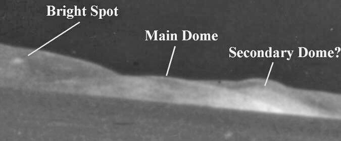
The North
Shore of Mare Crisium

AS10-30-4421 From 5 X
7 Sectional
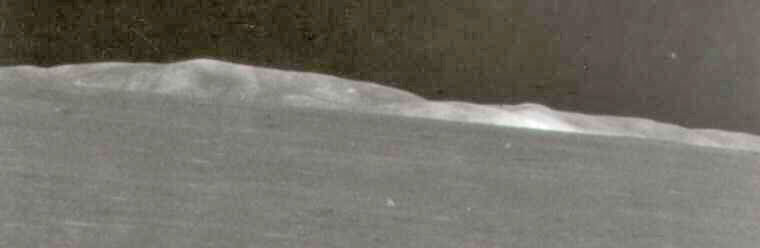
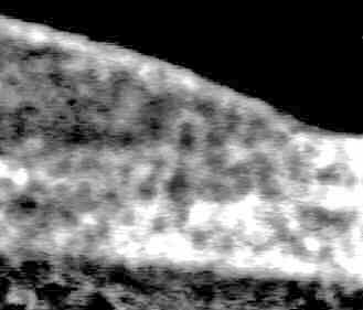
This is an unenhanced scan of Steve’s
original analog photo of AS10-30-4421. He first noticed the
very bright area in the right center of the image. A quick
examination of the 8 X 10 print showed that this area has the
highest albedo in the entire photograph.
Steve Troy’s
comments
I have been studying lunar anomalies on an analog level since 1994,
with an astronomical and stratigraphic interest in the moon for
several years prior to that. One of the key frames I have examined
is AS10-30-4421. This photograph is a view across the plain
of Mare Crisium emphasizing the crater Picard and the
North shore of the basin. This high-Sun oblique photograph is
centered at 55 degrees east longitude, 14 degrees north latitude.
I acquired the negative of AS10-30-4421 last February after looking
at the Apollo photographic catalogue SP-232
(1). In the catalog on
page 164, 4421 is considerably darker than the rest in the series
(4414 through 4420) that covers this region. I ordered it and was
surprised that it was of good quality and yielded excellent
sectionals. Other researchers including Lan Fleming of VGL,
have noted a number of anomalies, especially around the crater
Picard. However, in the far right portion of the frame there is an
anomalous object several magnitudes brighter than any other feature
in this picture.
It is also brighter than any other
natural or anomalous formation in the series 4414-4420. With an 8X
lupe and a light table one can see - upon examining sectionals of
this area - a transparent, Dome-like shape that apparently is along
the north Maria edge.
Its transparency is confirmed by tracing
the mountains behind the object, which are visible through this
immense dome like shape. I obtained other views of this area and am
currently looking at the whole Apollo Crisium "Series" with Mike
Bara. NSSDC has been most cooperative in responding to this as
well as all photo neg requests.
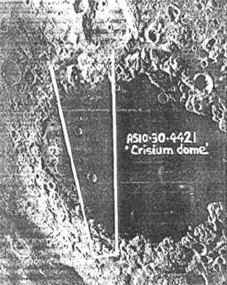
AS10-30-4421 image
map. Picard is the crater just to the lower centerof the frame.
Cleomedes F and
Cleomedes Fa are just to the right of the image edge.
4421 in is an oblique image taken
at high sun from an altitude of 60km. On vertical shots from Lunar
Orbiter 4 (191H3 and north Crisium close up, 51-H3) this bright
"Dome" can’t be seen.(2)
The Apollo 10 footprint maps show the angle of the photo.
Comparative angles overlaid on the Lunar Orbiter photos as well as
some Apollo 17 shots of the area show no such anomaly. It is my
belief that the dome must be seen at the right sun angle due to its
transparency and possible crystalline composition.
On the Lunar Orbiter 4 photos one can
see a small bright ray crater that it is situated just inside the
right 4421 footprint map photo boundary. The dome seen on 4421 could
not be this crater reflection because it is higher than the
mountains that tower over this region separating the northern
Crisium highlands & the maria. The mountains "Rise abruptly 3
kilometers above the flat maria area ".(3)
Scale must therefore be considered when looking at this feature
which is estimated to rise 3 to 4 miles vertically and 10-15 miles
horizontally from the maria floor area.
The Crisium basin is typical of large impact basins altered by
smaller impacts (Pierce and Picard are examples). There has been
basaltic volcanism and infilling by impact plains and mantels.
Geologic reports as well as several photos of this area are
available in the Apollo 17 Preliminary Science Report. It relates
"In the past mare history, deposits that seemed to have formed are
sheets of fine textured impact ejecta and fields of secondary
craters".(4) A
crystalline dome would not fit the parameters discussed in such a
geological report.
In March of 97, I sent prints and sectionals of 4421 to Hoagland,
and Mike Bara received them in August of this year.
Footnotes:
-
Apollo 10 Photography and Visual
Observations, NASA SP-232, p.164 +maps.
-
Bowker and Hughes, Lunar Orbiter
Photographic Atlas, NASA SP-206.
-
G. Heinken D. Vanimen, B.
French, Lunar Sourcebook, a Users Guide to the Moon,
Cambridge Univ. Press, p.11.
-
Don E. Wilhelms, AS17
Preliminary Science Report – NASA SP-330 Stratigraphic Study
of the north Crisium region, pp.29-29 through 29-35.
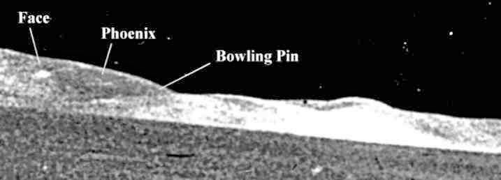
The first thing I noticed about Steve’s
analog five by seven sectional was the translucency of the dome. I
concur with his conclusion that the mountains can be seen through
the dome. I also note that it has 2 distinct "corners" or edges,
rather than blending in with the mountains behind.
This is highly unusual, as it seems to
stand apart from the mountain chain. In addition, I noted a bright
spot on the hillside just above and to the left of the main dome.
Immediately to the right of this bright object is a faint cross-like
object jutting from the hillside, and an odd spire or antenna
seeming to rise from the left slope of the main dome. I also believe
there is a second dome just beyond the right edge of the main dome.
It’s contour is visible through the body
of the main dome. It is more opaque from the perspective of 4421
than is the main dome, and the area where it overlaps the main dome
is the area of brightest albedo. This would be explained by
the light sources of the two domes adding their brightness as they
reflected the sunlight into the camera.
I believe there is a possibility that
the image map is in error and that the twin domes are in fact
covering the craters Cleomedes F and Cleomedes Fa. If
this is correct, then the craters are in fact not "craters" at
all.
Curiously, the entire image seems to be
oddly blurred, as if there were some fuzzy "Stuff" between
the camera and the north shore of Mare Crisium. Upon viewing these
characteristics of 4421 on my light board I immediately began
a series of image enhancements.
After scanning the image at both 300 and 600 dpi, I used a variety
of image enhancement techniques to bring out additional detail. I
used the high-pass and un-sharp mask filters and also applied gamma
correction and contrast enhancement. I was quite frankly stunned by
what these revealed.
Under enhancement, the less distinct
left edge of the Main Dome became more clearly defined, and
this helps to determine it’s location in front of the mountain chain
along the North shore. The now familiar translucent material is also
seen to be intervening between the camera and the domes, accounting
for much of the fuzzy quality and odd mottling apparent on the
frame.
Some have asserted that this pattern is
an artifact of the JPEG compression process, however, the original
data was from TIFF images which do not suffer from this "tile"
effect. This intervening material is also consistent with Richard
Hoagland’s assertion of a box like "dome" over the entire Crisium
region (Martian Horizons - The Journal of the Mars
Mission, Vol2, No.5, Frame AS16-121-19438). The Dome also
appears to have a cellular structure identical to the "Castle",
and the "Tower" seen in the famous Hoagland data.
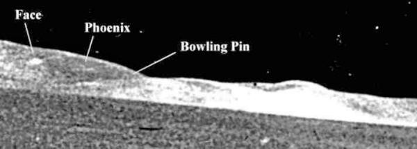
The anomalous "bright spot" now emerged as the top of a "headdress"
remarkably similar to the famous "Face on Mars".
The Face
The "Face", despite being somewhat distorted by the
semi-translucent material intervening between the camera and the
 object,
displays all the necessary characteristics to be included as a
potential monument. It has bilateral symmetry, a defined "Nose"
"Mouth" and "Eye-Sockets", and a proximity to other highly anomalous
objects. It is also isolated in the sense that there are no other
obvious "Faces" along the length of the North Shore visible in this
image. object,
displays all the necessary characteristics to be included as a
potential monument. It has bilateral symmetry, a defined "Nose"
"Mouth" and "Eye-Sockets", and a proximity to other highly anomalous
objects. It is also isolated in the sense that there are no other
obvious "Faces" along the length of the North Shore visible in this
image.
This strongly suggests that it is a
genuine feature rather than a collection of random bright and dark
spots in the image. The "Face" is also situated on the hillside
overlooking the "Dome", in such a way as to look down directly into
the center of the main "Dome".
Richard Hoagland has strongly
cautioned me about the tendency to see faces everywhere, but it is
important to understand that I am not suggesting that this object
resembles a face, but rather I am comparing it more precisely to the
Face on Mars at Cydonia. Given the "headdress" and
other features I believe it compares favorably to the Cydonian
structure.
On
his web site, researcher Dr.
Stanley McDaniel has proposed a system for classifying possible
new faces on Mars, his system uses 5 levels of priority ranking.
They are:
-
Type I: Facial sculptures
equivalent to the Cydonia Face in detail and appearance.
High priority for investigation.
-
Type II: Possibly Type I faces,
but lacking in sufficient information to be sure. Further
investigation warranted at second level of priority.
-
Type III: Non-type I but
containing sufficient detail and context to warrant
consideration as possible artificial. Priority depending on
degree of detail and context.
-
Type IV: Non-type I probably
natural features only accidentally resembling some kind of
"face." Low priority for investigation.
-
Type V: Obvious "jokes." No
priority.
Using this system, I propose that this "Crisium
Face" is a Type II. We will pursue other images in an attempt to
verify details.
 The
Phoenix The
Phoenix
The "Phoenix" is an odd cross shaped appendage rising from
the hillside next to the "Face". It is constructed of 2 cylindrical
objects interlocking with the vertical cylinder bending over to the
left, giving the impression of a bird with wings outstretched in
flight.
I have no idea what this object might
represent but it stands out dramatically from the drab mountain
chain it rests on and bears no resemblance to any explainable Lunar
geology. It reflectivity suggests a metallic or crystalline
construction.
This is reinforced by the fact that such
a rounded surface would not reflect this much light if were made of
typical "highland" material. Note that it is nearly as bright as the
"Dome" in front of it, which we have already established is made
from a translucent glass like material.
The
Bowling Pin
The "Bowling Pin" is a dark bulbous object just to the right
of the "Phoenix" which actually seems to protrude through the main
"glass Dome". This appears to be an antenna of watch tower of some
kind, and it’s middle portion is definitely obscured by the glass
like material of the "Dome" itself. Note how the upper tip of the
"Bowling Pin" is encased in the same glass like material and blots
out the upper rim of the "Dome" behind it.
Again, a spike like object such as this
has no place in standard Lunar geology, and I am at a complete loss
to explain it as anything but artificial.
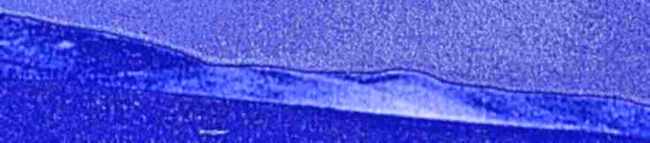
False Color
Enhancement
False color imaging provides another perspective on data such as
this. In this case I have separated the 32-bit color channels and
adjusted the Cyan into the blue range to emphasize shadows
and texture. Again note the geometric "haze" above the horizon and
the cellular structure of the 2 overlapping domes.

Conclusions
It is my opinion that the "Dome" or "Domes" are
real objects on the Lunar surface. There is no reason to suspect
that photographic defects or imaging artifacts account for their
presence. The "Face" "Phoenix" and "Bowling Pin" are all genuine
anomalies, not readily explainable by any natural process. Their
proximity to each other is only further reinforcement of their
artificiality. I must therefore conclude that they are all likely
constructs.
Part 2
Preface
These are follow up observations to my Crisium Dome discovery and
observations posted on this site on 9/13/97. It is suggested readers
access or reference "Glass Dome(s) in Mare Crisium?" on this site
for initial observations and pictures of the AS10-30-4421 Crisium
Dome.
AS10-30-4421 has revealed several anomalous features as noted by
Mike Bara and myself. I ordered this frame from NSSDC in March of
1997 and found, as reported, what I believe to be a crystalline
lunar dome located in the North shore area of Mare Crisium. After
thorough analog examination, it was sent to along with sectionals to
Richard Hoagland, and in ’97 to Mike Bara for computer enhancement
confirmation on this, and now other data we are working on.
After some discussion we agreed to order The AS10-30-4414-17 series
taken of this region. It was my decision to concentrate on two areas
- the fore-highland terrain areas and, what I believed to be a
bright crater area on the North shore area. Mike continued with the
North shore search. Before discussion on my areas, some Dome
location observations…
I can safely say that it is our shared belief that the Dome seen on
AS10-30-4421 can be seen only at certain sun angles. In the series
AS10-30-4421, the sun angle is high. However, the phase angle - the
angle at the point of intersection formed by the vectors from the
source (Sun) and the receptor (camera) - changed throughout the
sequence.
I believe the phase/Sun angles must be synchronized in order to see
the Domes in 4421. Much large-scale crystalline material has been
discovered and was photographed by Lunar Orbiter and Apollo
technologies. Much of it wasn’t captured due to un-synchronized
angles. Consider Apollo 16:
"One of the most intriguing orbital observations was made at
approximately 123:07 GET (3:01 C.S.T., Apr.21, 1972). The CMP was
watching the starts rise over the approaching sunrise horizon while
he was waiting to execute one of the zodiacal light photographic
sequences. While in a totally darkened cockpit, he noticed a bright
flash that appeared to the South of the ground track and several
degrees below the horizon. This flash was of very short duration and
did not remain long enough to permit recording a geographical
position." [1]
The 4421 Dome could be a "flash-unit". It is far brighter than any
landform seen on any photo in the 4414-4420 series.
I accessed frame AS11-42-6223 that shows a higher view of the whole
north shore area and sent the sectionals to Mike. There is a ray
crater that is extremely bright in the general location of the dome
that can be mistaken for it. This crater will be discussed. To play
the Devil’s advocate here however as I did, if one draws a line from
a common landform or crater on the terrain of the West shore seen
both on 10-4421 and 11-6223 up passing Picard to the right of the
dome area on 4421 and to the bright crater area on 6223, both lines
on these photos do seem to meet a point on the North shore near each
other. I am not convinced however, that the bright crater and the
dome are one and the same.
This "bright crater" area can be seen clearly on
LO-IV-54-H3
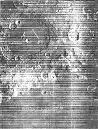
Figure 1.
If one looks at the AS10 footprint maps
[2] one can coordinate the
angle of 4421 with the 4421 photo. If the map angle lines are
correct (and the may not be, which I’m about to get into) the Dome
location according to it’s Selenographic location should be to the
left of Cleomedes F and Fa, two small Mare craters off the North
shore. The bright crater is located here. However, the Dome is
obviously seen as a much larger object that is transparent.
The three-mile high mountains on the North shore can be seen through
the dome on 4421. The 11-6223 photo enlargements and the
LO-IV-54-H
photo show the bright crater has merely splashed near shore. So size
is a critical factor here. If the Dome is a "flash-unit", it would
also not be visible under all conditions as this "bright crater"
seems to be. This small bright ray-crater is visible on almost any
picture of Crisium taken from any distance - even trans-Earth Coast
photographs.
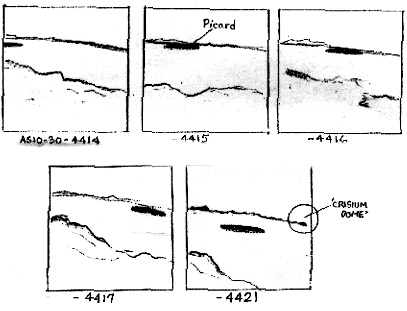
Figure 2.
In looking at the AS10 maps there are discrepancies. The photo
angles for the series AS10-4414-4417 contradict what is shown on the
actual photos. Map angles drawn for this series show Picard along
the left angle line border which is consistent for only one of the
photographs - 4414. Picard changed position as the spacecraft
orbited and by the time 4416 was taken, it was in the middle of the
frame. If these discrepancies exist it is reasonable to deduce that
perhaps the 4421 photomap angle may not be accurate.
I have not found the high albedo along with the transparency on any
object in pictures mentioned except the dome on AS10-30-4421.
A combination of factors that include Mike’s original enhancements
of the Dome, the "bright crater" area, and
the AS10 map angles here
all kept part of my research focused on this area. I came across a
frame in a NASA document that has not as yet been identified by
number and mission even though I’ve gone through all the catalogs.
Houston does not know yet either. It shows a possible confirming
Dome shot. It is currently being investigated by this team.
Sectionals were made of the "bright crater" area on frame 11-6223
and sent to Mike. Included were sectionals on the fore highland
areas of SW Crisium as well as Lick crater. No enhancements were
really needed for what was discovered in the area left of the bright
crater area. There is an astonishing, unmistakable and undeniable
architecture or archeology that I have named "Malibu", for it
reminds me of and clearly resembles California homes built into the
sides of hills but on a much larger scale.
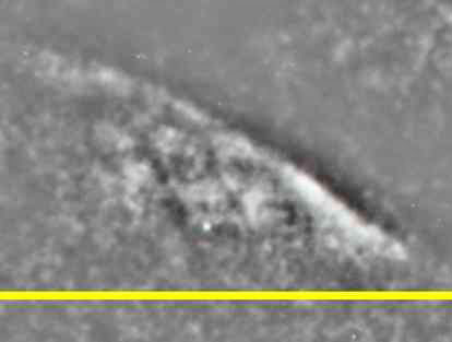
Figure 3. "Malibu". Yellow line indicates intersection of Mare plane
and highlands.
There are angular supports conforming to the physical relief of the
mountain slope. Within, are vertical trusses and horizontal beams
between them. It is sunlit and like the "bright crater", faces
south-southeast overlooking the Mare. After finding this remarkable
object, I returned to the AS10-4414-17 series as well as the
foreground shore areas of AS11-6223 to search for similar
structures. I discovered many smaller, rectilinear, concentric
complexes peppered throughout the inland edges of this Pre-Imbrian
basin.
On 11-6223 they are very clear and the orthogonal nature of
them can be seen with a magnifying glass on sectionals. They have
structural integrity and do not seem to fit within the traditional
geology of mere "hummocky-treebarklike" patterns. I consulted
geologic maps. [3] In the traditional stratigraphic model one does
see relatively degraded areas with mass wasting that has removed
material from and within higher areas that are now depressions.
There is a coarse patchy appearance in the steeper slopes along with
crater modification. The geometric complexes in these areas just do
not seem to fit within this model. (Fig 4). They cover inland areas
in the lower parts of frames 10-4414-17 and 11-6223 & seen more
clearly on 6223.
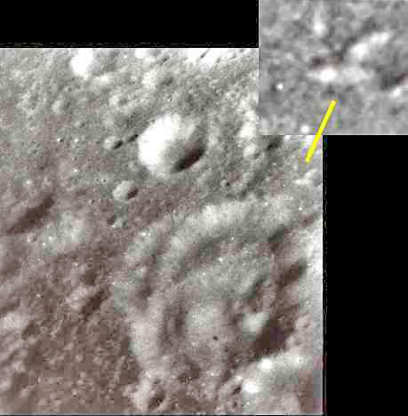
Figure 4. AS11-42-6223.
Two important observations take them out of the traditional model.
One is the fact that all of them, apart from the regular geometry,
are located on surfaces out of the path of further deposition and
wasting. The other is that the walls and height of these structures
appear higher than the natural terrain. For example, many are seen
along and near the rims of smaller 3-8 km craters and on plateaus
and relatively level areas.
Straight walls, within walls at geometric angles conforming to the
terrain do not just appear on levels higher than the highest point
of crater rims as these seem to do! And there is no endogenic reason
for their existence. If these were natural one would expect to see
such structures on a scale of these things all around the craters
where they appear and not such obvious locations and immense complex
form as these have. These to me all suggest artificiality and not
random manipulations of natural lunar geology. The central area of
Lick crater also reveals some similar shapes. Other frames from
different mission of this area are currently being examined. Stay
tuned.
Footnotes:
-
Young, J.W., Mattingly, T.K., Duke, C..M., Crew observations,
sp-315, Apollo 16 Preliminary Science Report, p.5-4.
-
Casella, C.J. Binder, A.B. Geol. Map of Cleomedes Quadrangle, I-707,
LAC44, USGS, 1972.
-
Olson. A.B., Williams, D.E. Geol. Map of Undarum Quadrangle, I-837,
LAC62, USGS, 1974.
-
Index maps, Apollo 10 Photography and Visual Observations, NASA
sp-232, 1971.
-
All images courtesy of NSSDC, Greenbelt, MD.
-
Apollo 10 and Apollo 11 photography 69-059A-01E - Principal
investigator Dr. Richard J. Allenby, Jr.
|