|
by
Keith Laney Many noteworthy anomalies can be found in the huge planetary imaging data bases we've collected over the decades. As the body of satellite data expands and the Apollo & other lunar photographic resources receive the proper attention they deserve, so also does the body of evidence pointing to possible advanced ancient human or extraterrestrial activities. That the ancients did have access to advanced technologies and science is evidenced by the giant structures and records they left all over our world. Many of these ancient records, such as the Sumerian and Indian epics Enuma Elish and Mahabharata, speak of space travels, aircraft, mighty weapons, terrible wars (even on the moon), and "gods".
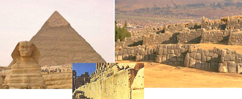
Some of the ancient megalithic structures survive to this day, and defy our modern ability to recreate them. The Great Pyramids at Giza, Sacsayhuaman, and the terrace of Baalbek are outstandingly good examples of this. In consideration of these evidences, it would seem logically sound thinking to look for similar structures on our planetary neighbors if we wish to find confirmation of the ancient testimonies.
It is my firm conclusion from research that the moon and our other neighboring planetary bodies harbor visual evidence of this type of activity, and this evidence is just as or perhaps more impressive than has been found on Earth. This is not only plausible, but also long documented and reported by many of the individual researchers that have honestly and open mindedly delved into our archived planetary imaging collections. Besides the numerous lunar archives scattered about in the Regional Planetary Image Facilities system, there are literally hundred thousands of digitized planetary images stored in the Planetary Data System, USGS, and Malin Space Science Systems.
Kennedy & Johnson Space
Center's online Apollo images are also readily accessible, albeit
incomplete, along with many other various NASA digital data resources. I am
one of the many that have plunged headlong into all the above, and as a
finder of many things anomalous in these planetary image collections, I can
personally and positively attest to this fact; all you have to do is look,
learn to recognize what you see, and carefully sift the signals from the
noise.
Upon closer examination, most of their reportedly anomalistic lunar
oddities were for the most part far too over scale, unresolved, and nonreferentially described to be warranted as convincing evidence for
artificiality. Although one must semi-admire them for trying to do something
with what limited resources were available at the time, and for drawing the
interest of many others more competent to handle the data, it is likely they
hurt this cause more than helped.
The first manned circumlunar
mission of Apollo 8 captured thousands of high resolution photographs of the
lunar surface. As with all the Apollo mission images these are referenced by
mission, film magazine, and frame.
AS8-12-2224 Now we will take a look at its higher quality sister image, taken moments later and from slightly farther to the right. I have the same object arrowed, and it is fairly visible in both of the size reduced full image examples displayed here. The two photos are very much the same in scale. They were taken by the same camera, with the only differences being the slight angle change between the two frames because of the distance the spacecraft had traveled westward. Note there is only a small position change difference between the two.
AS8-12-2225
To view AS8-13-2225 as
officially digitally represented go
HERE
AS8-13-2225 is evidently the better of these two images. For this reason I
chose it for doing the detailed sectional enlargements shown below. This
process is necessary in order to see the smaller and more delicately subtle
details that may escape notice due to the overall scale of the object and
its surroundings. The bicubic and bilinear resizing method was employed in
enlarging these high resolution digital photo examples. This method has long
ago proven its accurate effectiveness in increasing image size while
remaining true to actual photographic content.
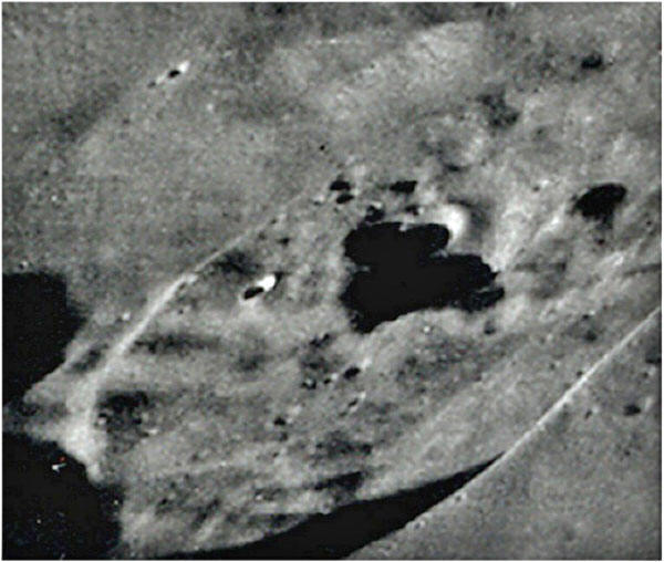
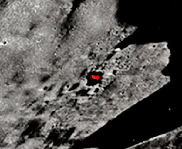
Using the officially stated size of the crater for reference, I estimate the general dimensions of the structure to be nearly four by three km. square at base, and better than one and a half km. tall. Notice the double line leading towards the left and right from the central area the object sits on, which is indicative of walls or perhaps a "causeway". The central complex is surrounded by visibly peculiar rectilinearities on all sides, indicative of additional outlying structure. These are attributes common to most archaeological ruins here on Earth.
There is a bit of damage from a small impact to the structure's far left corner, as evidenced by the little crater seen on its edge. On the right side and partially obscured by the shadow cast by the central structure ruin are two larger overlapping impacts. This would probably account for the further erosional destruction of the general area and collapse of the central structure. Now I'll take us in a little closer. On both this and the above image I've adjusted the contrasting a bit. This adjustment allows only the strongest structural edges to remain evident.
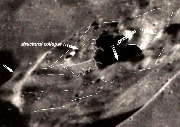
For the next image we'll review, I've used the digitized version of a negative-generated and sectionally enlarged analog photograph. Colleague Steve Troy obtained a negative copy from NSSDC, and had it developed by a professional photo lab.
The high quality and definition achieved from photographic enlargement using actual analog negatives affords us a detailed view of these peculiar features unobtainable by any other means providing the film is fresh. In this version, we are brought in close enough to see the individual structural components of this complex and the destruction that has resulted in its present collapsed appearance.
As in aerial archaeology, the main outlines of a ruined structure are clearly visible when viewed from further away, then fade somewhat as we move in closer. This property has resulted in the discovery of numerous ancient ruins by aerial means that would have otherwise been unrecognizable from the ground. That is what we see happening here, the seemingly sharp structural edges as defined above now show themselves to be dissolved a bit, as we would well expect from a ruined structure of this size.
Now that we are down in the crater with the wreckage, the complexity of the former structure starts to become clear. I've taken what I see as the main outlines of the larger structures and traced their edges. There are several arcologies I've arrowed along the roughly rectangular outer perimeter, also outlined.
Notice that at the lower part of the structure's bottom side are what may be arched openings. There is what could be a called "quonset hut" shape arrowed on the far left edge. In the middle of the large center structure is what could surely be termed a collapse, notice the depressed "window pane" appearance. All in all, I've seen actual verified ruins on Earth from the air that looked less artificial.
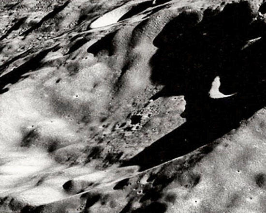
In order to check the validity of my claim that this is no common impact cratering structure, I reference a definitive source on lunar cratering morphology:
Here is a visual example they give of both simple and complex craters. Magelhaens A is an example of Nectarian crater. The others around it on this image are Nectarian as well, but it only has a raised, tiered, mare material free inner structure.
It is obvious from these images that all the craters in the vicinity both
large and small are simple, having flat bottoms and floors that are flooded
with thin mare material (Which is typical of Fecunditatis) except
Magelhaens
A, which has a magnificently tiered, right angled, stepped central structure
and no evident mare flooding.
The next structure with
similarities to the one as shown above was captured by Apollo 10 on the
second ever manned circumlunar mission. It can be found on NASA image
AS10-32-4823. This photo is among the best I've seen from the Apollo 10
collection, and can be readily found in the Greatest Images In NASA as
GPN2000-001487. If you would like to see it in full size you can find it
HERE.
AS10-32-4823 Unlike the two previous photos, AS8-13-2224 and 25, the lighting on AS10-32-4823 is from the upper right as the picture is oriented, or west. This creates nearly an opposite shadowing effect from what is seen in the previous images. Like the others, this one contains many other oddities we will forego. Although represented much smaller than actual size here, the photograph is still noticeably strong on clarity.
This property makes it
very suitable for both enlargement and surface analysis. Apollo oblique
frames offer us a great wealth of information about lunar surface detail.
The elevations and angles of three dimensional structures combined with the
effects of depth and lighting combine to give us a more accurate perception
of the shapes and properties of intricate surface features. These features
might otherwise be unidentified given higher viewing angle and lighting. The
arrow in the full image above points into Stratton K and at the structural
object, which is near the crater's center..
This object is not as highly elevated, or on a "platform" like the one shown on AS8-13-2225, and of course this one sits in a crater which is larger by 9 km. Nevertheless, the similarity of these features is remarkable. Most strikingly similar about it are the tiered layers.
The object's shadow is cast over a depression and reveals its general shape on the surface behind it, much as the object in Magelhaens A's shadow does the same over the depression in front of it. As with the first structural anomaly, I applied bicubic and bilinear sectional enlargement to bring us in a bit closer for a more detailed look.
I estimate it also to be nearly
four by three km. square at the base and
close to two km. tall. Damage has been acquired over time on this one also,
evident by the couple small impacts around it. The similarities of this
structure to the one in Magelhaens A, which include overall estimated size
as well as the geometric items lying nearby, strike me as being more than
merely fascinating. I see an emerging pattern. I cannot help but to be
observantly speculative and state that these do seem to resemble some degree
stepped pyramid based complexes with associated surface structures, very
much like many of the ancient monumental structures here on Earth.
Image sources credited to
NASA, USGS, Malin Space Science Systems,
Steve
Troy, The Oriental Institute at the University of Chicago.
As if two of these objects on
the Moon weren't enough! Click
HERE
|