|
Study 3: Avian
formation on a South-facing slope along the Northwest rim of the
Argyre Basin
by:
Wilmer C. Faust
Keith Laney
William R. Saunders
George J. Haas
James S. Miller
Contributing DVMs:
Doctor A. J. Cole
Doctor Joseph M. Friedlander
CONTENTS
Back to Contents
Abstract – James S. Miller
This is a description of a feature that rests against a web of
structural components found on a mound within the Argyre Basin of
Mars in Mars Global Surveyor image M1402185 (Figure1
below). There are
defining aspects of this feature, which when taken together induce
the visual impression of an avian formation. Adjoining this
formation is a composite of cellular features that form a
compartmentalized infrastructure. The topography and the geology of
the formation is examined and compared to a random example of
circular mounds and sediment ponds found in the Dao Vallis Region.
A list of other sites is provided that
is similar in nature but do not produce a similar feature. Two
veterinarians provide a critical analysis of the avian features and
an independent geo-scientist provides an analysis of the
topographical mechanisms required to shape these features. Finally
an overview of the topography is given.
This analysis will indicate that there are too many avian features
present in this formation to suggest that it was the result of
random forces. Natural forces in the area are seasonal and have
occurred over the millennium. In only 6 years of natural weathering
occurring in the same sequence the odds of an isolated effect would
be 1 in 46,656. Otherwise, it is 1 in 36 if it occurs only once.
The
basic underlying question is; what are the chances of seasonal
effects occurring only once? In other words, the avian formation
appears to have permanence. No possible combinations of natural
influences on the landscape could have altered the image without
erasing some part of the feature. The overall impression of this
feature as opposed to those, which are found naturally occurring, is
that this approaches a work of art in its completeness. A
terrestrial comparison is also offered, suggesting an aesthetic
origin.
To Top
History – Keith Laney
On March 7, 2002 independent researcher Wilmer Faust presented an
odd hillock formation captured in MOC image M1402185, to our
attention. The rectangular areas along the upper edge of the hillock
on an S-facing slope along the Northwest rim of the huge Argyre
Basin are what interested him most. Faust noted compartmentalized
structural features throughout its topography including a formation
reminiscent of a gigantic bird.
Images showing the feature and obtained for this study were
processed from raw data imq files via MSSS, subjected to the same
established procedures used in the processing of the MER2003 landing
site selection MOCs. MOC images, though high quality, rarely
decompress from IMQ into a quality high enough for detailed viewing.
The compression artifacts, data drops, and streaking inherent due to
the nature of the camera and data transferal methods are actually
only a slight hindrance. They can be removed from the images with a
little finesse and the appropriate software.
What follows are general steps used in decompressing, de-streaking,
clarifying, contrast adjusting and optimizing MOC images into file
size manageable yet quality .PNGs.
Processing Steps
1. Decompression
Decompress the .imq or .img file using the software of your
choice. A preliminary visual evaluation of the image can be done
now. Proceed to save it in uncompressed format for further
processing.
2. Dealing with Dropouts (if applicable)
Open the image in image editing software.
* If the image is
error free, and clear of data drops (bands that run across the
images in black/white strips or “fuzz”) save it as a .raw file,
and note the image size (***x***** pixels)
[or]
* If error bands or other data drops are visible further
steps must be taken as follows:
. Using the select tool set on rectangular shape, surround the
errors and cut these damaged areas from the darker albedo
images, or . Flood fill color them in solid black on higher
albedo images. . Save these corrected images as a .raw image and
note the image size (***x*****)
You lose those areas, but they are damaged and unusable anyway.
Take care to get them all. Left there they spread through the
histogram and distort the de-streaking and adjusting process.
3. De-streaking
The raw image is then de-streaked using a comb filter.
4. Final Enhancement
The resulting de-streaked image is then
opened in imaging software and finely tuned.
Apply clarifying, contrast & gamma adjusting, sharpening and various
other filters gently, noting the results on the histogram as the
grayscale potential begins to take good shape, with the surface
details becoming clearer and better defined as the albedo
differences are defined more sharply. The image was saved in PNG
format and minimal compression.
Final Notes
The average human eye has the ability to differentially
recognize between 12 to 16 shades of grey . Best results are to be
had when the widest variety of these 12 shades is distributed evenly
across the image.
After processing, the images were then aspect corrected using the
figures given in the image’s ancillary data, oriented N/S, and file
size optimized. All images in this study have been aspect corrected
but not map projected, which was unnecessary to the content.
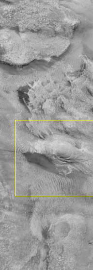
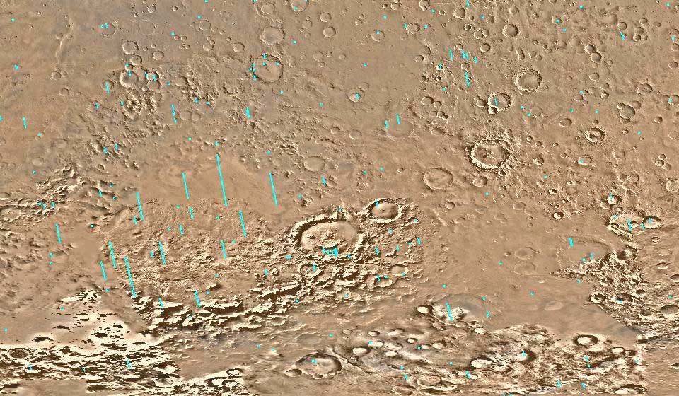
Figure 1
The Parrotopia Complex (M1402185)
Image courtesy Keith Laney
Note the profile of a full-bodied bird at the upper most portion of
this strip. The image is presented north south oriented and the
feature is boxed in yellow. It should be noted here that NASA
provides a north south orientation and a version as seen by the
camera as it passes over the surface. This means that the image is
oriented in both directions on the NASA site.
To Top
Avian Geoglyph at Argyre Basin – Wilmer
C. Faust
The following descriptions denote the anatomical features of the
proposed parrot formation that are detected within the source image
M1402185 (Figure 2). Starting at the head the mandibles appear
correctly shaped and illustrate typically serrated aspects in the
appropriate locations.
The mandibles appear hinged and
partially opened, revealing a tongue feature nested in the upper
beak. There is evidence of a cere, just behind the upper mandible,
with the suggestion of a nostril.
The eye appears correctly positioned and illustrates its typical
aspect when a parrot is looking forward as viewed from the side. The
remainder of the frontal and lateral aspects of the head gives the
visual impression of a light colored eye patch, which is a very
prominent aspect of many parrots.
Behind the hood line of the neck is the main body of the bird. In
comparing the shape of the breast to the exposed back between the
wing covers, to the wing cover size itself, the head size and the
overall body length appears correctly proportioned. The wing covers
are remarkable in their accuracy, in particular the lie of the
feathers when the wings are folded.
The left leg structure is represented with a visible
clawed foot.
Finally, the area that forms the tail feathers is somewhat less
distinct. This is due in part to the fact that a portion of the tail
feathers are cut off by the edge of the source image providing only
a suggestion of such a feature.
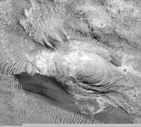
Figure 2
The Avian Formation
(Detailed crop of M1402185)
Image courtesy Keith Laney
To Top
Geological analysis – William R. Saunders
This area contains many non-conforming and complex features (Figure
1) however it is the parrot-like formation that is of most interest
and will be discussed here. The avian structure in question is
composed of five segments: the beak, the head, the neck, the body
including left wing and tail feathers and the legs/feet (Figure 3).
These segments are differentiated by structure, albedo effect,
patterning and possibly lithology.
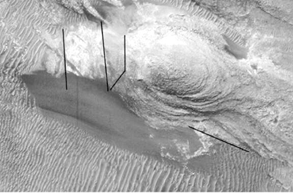
Figure 3
Five Segments of the Avian Formation
(Detailed crop of M1402185 with line annotations by William R.
Saunders)
Image courtesy Keith Laney
The central mound (according to the veterinarian’s analysis) which
forms the body, left wing and tail is most likely composed of
sandstone or siltstone and has striations which give the impression
of feathering. Initial interpretation is that these markings are
caused by erosion of horizontal stratigraphy by lateral water action
or wind erosion. It would seem that an almost cyclonic wind action
occurring at one place over a long period of time would be needed to
form the circular “feathered” wing striations.
The surrounding dunes however, indicate
prevailing winds from west to east which would not expose the east
side of the mound to abrasive wind erosion. It would seem that an
almost cyclonic wind action occurring at one place over a long
period of time would be needed to form the circular “feathered” wing
striations. Another hindrance to this explanation is that this type
of violent wind process or the necessary water action is not evident
elsewhere in the surrounding area.
The upper portion of the neck (Figure 5 F) is obscured by talus or
mass flow material from the mound. The lower portion of the neck
appears to be a continuation of the mound; however its multi-layered
truncation is irregular and does not conform to the layering pattern
seen in the body/wing.
If this irregular edge were caused by
folding there should be evidence of disturbance on either side,
which there is not. The texture and albedo of the face (Figure 6 L)
is anomalous to the area and shows no evidence of fluvial or wind
erosion or deposition consistent with what would be necessary to
form the striations seen on the body. There is a large mound or
pyramidal structure exactly positioned in the location of an eye
(Figure 5 &6 C). Shadow highlights this effect.
The lithology of the beak appears to be an isolated composition with
irregular patterning on its surface (Figure 4). What could be
considered to be cross faulting and or block faulting conveniently
separates the beak from the face and forms the mouth, tongue and
crown. Evidence that faulting has occurred at all is indeed arguable
as it would have to be extremely localized and multi-directional as
there is no evidence of faulting in the dunes around this feature.
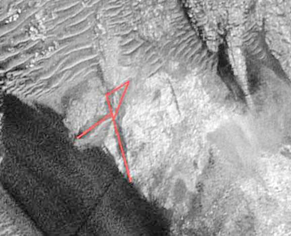
Figure 4
Multi-Directional Contours
(Detailed crop of M1402185 with line annotations by William R.
Saunders)
Image courtesy Keith Laney
Another anomalous aspect to this parrot-like structure is the dark
material beneath it that extends from the feet to beyond the beak
(Figure 5 N & H). This dark material appears to be aeolian detritus.
It is suggested that this material is composed of iron pistolite
weathered from the mound. This material has an air brushed
appearance and does not form dunes. If it is wind deposited, its
trapping mechanism is suspect.
Lastly the legs/feet (Figure 5 O, N, P) are note worthy in that one
would anticipate the composition to be of the same material as the
body and tail, however their structure is multi directional and
generally perpendicular to the body and tail. Conveniently for the
viewer, neither the dunes nor the dark material obscure them. It has
been suggested that faulting, possibly active, is at work forming
the legs and feet.
Once again the faulting would have to be
conveniently localized.
In conclusion, given the lack of similar lithology and evidence of
similar geo-processes in the immediate area, this structure is
indeed anomalous. Numerous geomorphologic and geological processes;
including, non-extensive, multi-directional faulting, erosion and,
deposition all occurring at exactly the right place and time would
be needed to produce this structure.
To Top
Veterinarian Analyses of the Anatomical
features of the Avian formation – Doctor A.J. Cole and Doctor Joseph
M. Friedlander
Two veterinarians have
examined this avian feature exhibited within the Argyre Basin. The
first doctor was aware of prior theories of artificial objects on
Mars, while the second doctor had no prior awareness of any theories
of artificial objects on Mars. Both doctors impartially and
independently evaluated the features of the proposed avian
formation, having access to both a printed hard copy and
computer-displayed image of the complete formation.
Doctor A.J. Cole:
Jackson Veterinarian Hospital,
Jackson, New Jersey
There are distinct anatomical similarities to the features found
on the formation located at Argyre Basin and the avian species.
Centrally there appears to be a midstructural breast and abdomen
with protruding structures resembling primary flight feathers
with feather shafts attached to the dorsal aspect of the image.
On the left (rostral) aspect of the structure there is a
resemblance to head and facial features ending at the nape of
the neck. The head includes a lateral left eye, a hinged beak
with a blunted tongue between a parted lower mandible. Between
the “eye” structure and beak there is an arching structure
resembling a cere without evidence of a nostril that may be
obscured by a crest or comb feature.
Below the abdomen (ventrocaudally)
there appears to be a claw feature consisting of a three or
four-toed foot with a bend at the equivalent of the tarsus.
There is only a hint of a paired second foot, which is
unresolved. The structural formation to the far right of the
body (caudally) resembles tail feathers; however no inference
can be made about a tapered or blunted tail in the available
image. The following analytical drawing (Figure 5) identifies a
set of 17 points of confirmation that Veterinarian A.J. Cole
believes provides evidence that the formation at Argyre Basin
not only represents an avian creature, but it’s sculptured
features appear anatomically correct.
Figure 5
Parrotopia Formation
Analytical Drawing with notations by Doctor A.J. Cole.
Drawing by George J. Haas
(Image source: M1402185)
A. Cere. B. Crest. C. Eye. D. Primary Flight Feathers (right
wing). E. Feather Shafts F. Hood Line (neck). G. Body (folded
left wing). H. Beak. I. Tongue. J. Jaw. K. Head. L Abdomen. M.
Claw. N. Foot and Toes. O. Tarsus Joint. P. Tibia. Q. Tail
Feathers.
Doctor Joseph M Friedlander:
Adamston Veterinarian
Clinic, Brick, New Jersey
Examination of the formation at Argyre Basin reveals features of
the avian species. Rostrally (left), one can visualize the beak
with its maxilla mandible surrounding the tongue. Features of
the head are clearly visible. The cere is noted dorsal to the
maxilla. The orbit, papillary margin and opening of the external
ear canal are evident. The head looks featherless. Down feathers
are seen in the cervical area. Visualized in the thoracic region
is the left wing folded in a natural position. Primary feathers
cover this region. Ventrally is the pectoral area ending at the
point of the keel.
Caudally (to the right) is the
abdomen and left pelvic limb. Three digits, tarsometatarsus and
tibiotartus are visible. The photograph includes the proximal
portion of tail feathers. Just rostral and dorsal to the tail
feathers is a change in feather pattern of the pygostyle (prcen
gland). The following analytical drawing (Figure 6) identifies a
set of 10 points of confirmation that Veterinarian Joseph M.
Friedlander believes provides evidence that the formation at Argyre Basin
not only represents an avian creature, but its
sculptured features appear anatomically correct.

Figure 6
Parrotopia Formation
Analytical Drawing with notations by Doctor A.J. Cole.
Drawing by George J. Haas
(Image source: M1402185)
A.Cere. B. Part of Crown. C. Eye. D. Ear. E. Down Feathers F.
Folded Wing.
G. Preen Gland H. Tail Feathers. I. Maxilla. J. Tongue. K.
Mandible. L. Face.
M. Abdomen. N. Digits. O. Tarsometatarsus. P. Tibiotartus
To Top
Comparison of a random feature on Mars at
Argyre Basin – William R. Saunders
Conducting a random search of the surrounding area of Argyre Basin
no suitable comparative features were found. Subsequently a search
was expanded to the outer regions, in which a comparable feature was
found with similar contours within the Dao Vallis region of Mars.
The comparable mound feature from Dao Vallis is displayed in Figure
7 and a cropped portion of the Argyre Basin formation is displayed
in Figure 2.
The appearance of sand furrowing
indicates water has surrounded both of these landforms in the past
leaving island remnants. The mound from the Dao Vallis region shows
a typical oval shape expected from the movement of water around the
feature with a slightly truncated left side and a small point bar on
the right. In contrast, the multiple features exhibited in the
formation found at the Argyre Basin area do not present the same
expected characteristics.
There is no truncation on either side, nor
is a point bar formation present. The formation at Argyre Basin
(Figure 2) also has what would appear at first to be multilayered
strand lines that are not present on the mound at Dao Vallis. The
conclusion being that the formation at Argyre Basin has undergone
post fluvial alteration.
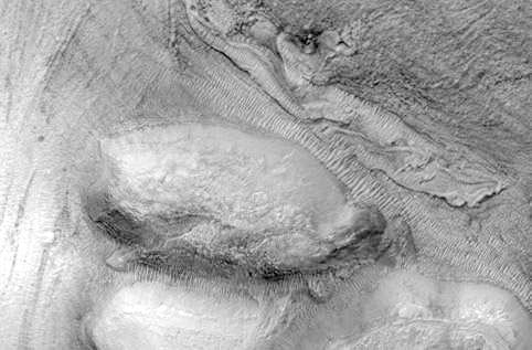
Figure 7
Mound Formation at Dao Vallis
Crop from MOC Image R1502471 –
rotated right 90°
Image courtesy of Keith Laney
To Top
Aesthetic analysis – George J. Haas
The formation at Argyre Basin appears to be the result of a
composite structure of unrelated geological materials that were
altered to express the prominent features of an avian creature. The
topographical features appear to include an oval shaped mound that
conforms to the shape and size of a bird’s body including a folded
left wing (Figure 5G). Adjoining features to the left side of the
body-shaped mound suggest a composite of structural elements that
resemble a bird’s head (Figure 5K). The head includes an eye
formation (Figure 5C) and a parted beak (Figure 5H) with a fleshy
wattle-like crest (Figure 5B). Additional elements form an extended
left leg (Figure 5 O&P) and clawed foot (Figure 5 M&N).
There is also evidence of an extended
right wing along the back (Figure 5D) and tail feathers (Figure 5Q)
that may extend beyond the image. The majority of comparative
examples of manipulated terrestrial geology come to us in the form
of earthworks that were created by ancient cultures throughout North
and South America. Because there are a limited number of examples of
animal and figurative earthworks in the available database, only two
meet the criteria of this study with comparable detail and content.
The first is a 5,000-year-old eagle shaped Geoglyph located in the
town of Eatonton Georgia. A bed of quartz stones form a silhouette
of an eagle hovering within a circular mound. The body measures over
100 feet from head to tail and has a wingspan of over 120 feet
(Figure 8). The overall shape of the eagle is symmetrical in design,
featuring a set of out stretched wings, tail feathers and a head
that faces eastward.
As seen in the illustration, its contours
project only the simplest form of a bird without providing
additional details.
Figure 8
Eagle Effigy Mound: Eatonton Georgia
Drawing by George J. Haas
(Image source: National Geographic, vol.142, no.6, page 784)
A second example of an avian earthwork
is etched on a hillside in the Peruvian Andes, not far from the
famous
Nazca lines. The Peruvian pictograph is formed by a set of
conjoined lines that create the impression of a standing bird
(Figure 9). Although the awkward shape of the Peruvian pictograph is
not anatomically correct, the overwhelming consensus is that it
indeed represents the generic form of a small bird.
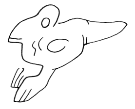
Figure 9
Bird Pictograph Nazca.
Drawing by George J. Haas
If this simple mound and hillside
rendering are accepted as intentional works of art by aerial
observations, then it would be reasonable to say that the formal
organization expressed within the Martian feature is not the result
of mere chance. This is beyond the modeling of relief sculpture and
there are no terrestrial Geoglyphs that induce such a visual
impression, as seen within the avian formation at Argyre Basin.
To Top
Regional Context -Wilmer C. Faust
The site of the complex of features we have identified lies within
the northwest quadrant of the Argyre Basin, which is centered on the
planet Mars at about 50 degrees south latitude, 43 degrees west
longitude Figure 12. The result of an ancient impact, the Argyre
Basin is the second largest cratered landform in the southern
hemisphere of the planet. It is ringed by ramparts rising several
kilometers above its central plain, known today as Argyre Planitia,
and is of roughly circular but somewhat irregular outline likely
resulting from environmental alteration subsequent to the primary
impact event.
Figure 12
MOC planetary map showing the location of the M14 Series of images
with the exact location of M1402185
Annotated by Jim Miller Original
map at this address:
NASA/JPL/Malin
Space Science Systems
The encompassing Basin scarps and bluffs
are in turn surrounded by the generally more greatly elevated
Southern Highlands. Within the Basin is found a prominent but much
fragmented zone of rugged elevations, the Neiridium Montes, mainly
concentric with and extending from or near to the defining ramparts
approximately one-quarter of the diameter of the Basin towards the
central plain.
The Neiridium Montes are sufficiently prominent to
give a geophysical character possibly unique on Mars to the Basin
itself, with prominent elevations alternating with much lower institial plains and valleys more closely approximating the lower
elevations of Argyre Planitia. See Figure 13 for a graphic depiction
of this description.
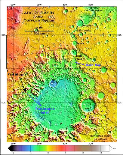
Figure 13
MOLA image of Argyre Basin
(Annotated Map by Wil Faust)
From a previously published study based on topographic data produced
by the Mars Orbiter Laser Altimeter instrument (MOLA), it is now
known that at least once and perhaps more often the Argyre Basin was
an outflow source of water which emptied through a sequence of
lower-lying landforms toward the north-northeast (Figure 13). A
thorough assessment of the archaeohydrology of the Argyre Basin is
beyond the scope of the present examination. It is important here to
note that this area is near an inferred old polar cap, and some of
the geology is remarkably similar to southern Polar Regions.
To Top
Conclusion -
Wilmer C. Faust, Jim Miller, George
J. Haas, William R. Saunders
The overall impression of this area is
that regardless of the nature of the rock and sediment, the nature
of depositional and erosional forces, the avian formation is indeed
an anomalous structure when compared with the rest of the
topography. While there are known geological mechanisms that could
have created the anatomical accuracies presented in this formation,
it is highly unlikely that the entopic effects of environmental
degradation could have produced such prominent orientations and
postural representations at the same time, in the same place within
a 1.5 square mile area.
With respect to the modeling of these
anatomical features the visual perceptions of this avian formation
suggest it’s the result of an organized design as opposed to an
illusionary projection. Therefore it is conceivable that this avian
formation was originally a natural landform that was artificially
modified to illustrate all the required features and details of a
recognizable bird.
To Top
Biographical information about the
authors:
-
Wilmer C. Faust III acquired a
Bachelor’s degree in Anthropology from Dartmouth College, NH,
and a Master’s in Urban Planning from Penn State Harrisburg. He co-founded the Historic Harrisburg Association and his
memberships to scientific and research organizations include the
American Institute of City Planners, Harrisburg Astronomical
Society, SETI, Anomaly Hunters and Project Teardrop.
-
George J. Haas is a sculptor and a
former director of the Sculptors’ Association of New Jersey. He
is a member of both The Pre-Columbian Society at the University
of Pennsylvania and The Pre-Columbian Art Research Institute in
San Francisco California and is the co-author of the book
The Cydonia Codex - Reflections from Mars.
-
Keith Laney is a digital-imaging and
software applications specialist, known for his imaging
contributions to NASA History, the MER2003 Rover missions and
NASA’s Landing Sites Project. He is also working on the complete
Apollo program image archives for NASA/JPL
-
Jim Miller is an independent
researcher and the founder of a Mars research group where this
feature was first presented and discussed. He has also written
and edited several company newsletters.
-
William R. Saunders graduated from
the University of Alberta in Edmonton in 1977 with a Bachelor of
Science degree in geomorphology. He currently works as a
petroleum geoscience consultant in Calgary, Alberta, Canada. He
is the co-author of the book
The Cydonia Codex - Reflections from Mars.
Contributor:
Keith Phillips is an engineer. He
worked at 7 different Silicon Valley startup companies as a
manufacturing engineer, engineering supervisor, applications
engineer, applications engineering supervisor, technical support
supervisor and microwave and semiconductor engineer.
To Top
FOOTNOTES:
-
Keith Phillips provided the
mathematical, statistical computations NASAView 2.5.8 or
equivalent decompression software recommended Paint Shop Pro
or Photoshop recommended Comb2 or Mocomatic digital image
comb filter recommended
http://www.engr.udayton.edu/faculty/jloomis/ece563/notes/color/GrayScale/grays.html
http://chesapeake.towson.edu/data/all_image.asp
-
The following list represents
the data set of MOC images that were examined by George J.
Haas, Jim Miller and William R. Saunders in an effort to
locate a comparable image to the Parrotopia formation
observed in MOC image M1402185.
Those images include:
-
M04-00606 North facing slope
of crater.
-
M04-00926 Argyre Basin rim.
-
M13-00036 North Western
Argyre Basin.
-
M13-00220 SW Argyre Planitia.
-
M13-00471 Traverse of
Mountains W of Argyre Planitia.
-
M20-00992 sample terrain in
SW Argyre Rim Mountains.
-
R15-01672 North Central
Argyre Basin.
-
R15-01571 sample mountain
plain west of Argyre.
-
R15-01194 North Eastern
Argyre Planitia.
-
Wilmer Faust wrote his sections
of the paper prior to his untimely death on 7/25/2005. There
were extensive descriptions and dissertations regarding the Argyre Basin, its hydrology and possible theories for the
placement of this feature in this location. All of this
material was beyond the scope of this paper but is preserved
on a web site dedicated to the continued research of this
feature.
To Top
|