|
CHAPTER FIVE
How could this have been known without an aerial survey of the Earth?
In this chapter, I shall be reviewing some of the best documented, irrefutable examples of ancient science -examples which can be physically seen in sites or in museums. I will be focussing particularly on several ancient civilizations which possessed advanced astronomical knowledge.
This extraordinary knowledge can be ignored, but it cannot be denied. Some scientists have bravely tried to explain the existence of this knowledge with the suggestion that the ancient civilizations needed astronomy to tell them when to sow and reap their harvests. I am not joking! This idea is repeated ad nauseam in our text books.
Here, for example, is one quote concerning the ancient Maya of Mesoamerica:
What preposterous nonsense! I am sure that farmers today would feel quite insulted at the suggestion of consulting an astronomer for guidance on the change in seasons. Here are a few basic truths that should squash this myth once and for all: first, whenever primitive societies have been found in the world they have managed to feed themselves and survive without astronomy or a calendar.
Secondly,
the calendar was invented by an urban society at Nippur in Sumer,
not by an agricultural society. Thirdly, the astronomically aligned
site of Stonehenge in England was originally laid out when no
organized agricultural society is supposed to have existed in that
area.
The suggestion that mankind developed
advanced astronomy and built complex observatories for “religious”
reasons is equally intriguing. Somehow we are expected to believe
that our ancient ancestors worshipped the wind, the rain, the Sun,
the Moon, and so on, and built sophisticated observatories and
temples to watch and to worship the movements of these “Gods”.
The Maya
deserve more credit than that, and so do the Egyptians and the
Sumerians. As we take our tour through the “impossible” ancient
sciences of geography and astronomy, we must ask ourselves how and
why these sciences arose, and we must reassess the motivations of
our ancient ancestors.
Between 1519 and 1522, the Portuguese navigator, Magellan, sailed
nearly all the way down the South American coast.’ In 1530,
Francisco Pizarro, the Spanish adventurer, sailed from Panama to
Peru; he returned years later to conquer Peru and to explore inland
and further down the coast.
The second Piri Re’is map, dated
1528, covers Greenland, Labrador, Newfoundland, the east coast of
Canada, the east coast of North America as far down as Florida, and
Cuba. It is suspected that a third map showing Europe, Asia and the
Indian Ocean may also have existed. The most amazing thing about the
Piri Re’is maps is their level of detail and accuracy. The eastern
coast of South America in the 1513 map is charted all the way to the
Patagonian tip, a coastline which, in its entirety, was supposedly
unknown at that time.
Even more
remarkably, the Piri Re’is maps accurately depicted the topography
of Antarctica, together with its islands, rivers and coastline. Yet
Antarctica has been covered by a one mile thick layer of ice for
thousands of years! Officially, this land was only discovered in
1820, and it was only between 1957 and 1960 that a comprehensive
seismic survey revealed the true nature of Antarctica as a large
continent with high mountains. As the Piri Re’is maps were
discovered in 1929, 28 years before modern science was able to probe
the features beneath the ice, they cannot be accused of being
fraudulent.
An investigation by the American cartographer Arlington Mallerey initially found all of the Piri Re’is features to be correct but in the wrong places. Subsequently, with the help of Mr Waiters, a cartographer from the US Navy Hydrographic Bureau, he constructed a grid from the maps and transferred it to a globe. The perfect accuracy of the resulting map indicated an advanced knowledge of spherical trigonometry which stunned the scientists. Following further studies of the maps, a press conference was held on 28th August 1958, supported by the US Navy Cartographer.
The organizers stated:
The Piri Re’is maps are not alone. Other ancient maps of the world such as the Oronteus Finaeus map of 1531 and the Zeno map of 1380 have been subjected to similar scrutiny, with similar results. Regarding the Oronteus Finaeus map, which also showed Antarctica’s now hidden geographical and topographical features, Captain Burroughs, Chief of the US Air Force Cartographic Section concluded:
Some of these ancient map-makers clearly attributed their knowledge to other even older maps, which once existed, and it is possible that they in turn date back to the time of the Phoenicians, the famous seafarers from the first millennium BC. But where did the Phoenicians acquire their knowledge? All of these maps have caused a fundamental rethink of the knowledge possessed by ancient civilizations.
Charles Hapgood summed up his findings as follows:
The Antikythera Computer
Whilst maps are clearly useful when in sight of land, how could they have been used for navigation when in the middle of the Atlantic? Charles Hapgood was severely criticized for daring to suggest that : It is clear, too, that they had an instrument of navigation for accurately determining longitudes that was far superior to anything possessed by the peoples of ancient, medieval, or modern times until the second half of the 18th century.
However, in 1979, Maurice Chatelain, a former NASA scientist, came up with an ingenious solution to the mystery. Chatelain proposed that the ancient mariners took with them pre-calculated tables for sunset and moonrise time differences calculated for every day of the year. They then established their longitudinal position at open sea by comparing the actual intervals of sunset and moonrise to those charted for their home port. The elapsed time was measured by batteries of hour-glasses.
Thus, according to Chatelain:
In the National Archaeological Museum in Athens is an artifact which could well have been used in the navigational method described by Maurice Chatelain. The strange object was discovered in October 1900 just off the coast of the small island of Antikythera, which lies west of Crete in the eastern Mediterranean.
At a depth of 180 feet, some Greek sponge divers came across the wreck of an ancient ship, complete with cargo. Among the cargo was a large collection of art in the form of vases, marble and bronze statues, which was retrieved and sent to a museum in Athens.
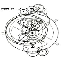
In 1902, Valerio Stais, a young Greek archaeology student at the museum, was ordered to sort out the various broken and miscellaneous pieces. It was then that he found a small, calcified lump of bronze that, whilst drying, had split in half to reveal what looked like the inside of a large watch, with gears, pinions, dials and ancient Greek inscriptions. After a further search, the young archaeologist found that there were four main pieces and some smaller lumps, which he cleaned and reassembled.
Although some parts of the device were missing,
presumably still on the sea bed, Stais was able to identify a
sophisticated and complex mechanism, comprising about forty
interlocking cog wheels (gears) of various sizes, nine adjustable
scales and three axes on a base plate. The precision of the device
can be judged by the fact that the central cog had 240 teeth, each
only 1.3 millimeters high.
The device was thus registered in the museum as a simple
astrolabe, even though the medieval astrolabes a millennium later
were mere toys in comparison. The huge number of gears was
conveniently overlooked, as was the fact that the device had been
made in bronze rather than the more easily malleable brass which was
used for medieval astrolabes.
He found gears, dials and graded plates, assembled from at least ten separate parts; gears linked on several differentials that incorporated the cycle of the Sun and the 19-year cycle of the Moon; gears fitted with tiny teeth, which moved on various axles - all made to an incredible precision (Figure 14). Decipherment of the dials and graded plates suggested that the device was used to show the position of the Sun in the zodiac, the phases of the Moon and the movements of the planets.
Price summarized his findings as follows:
Whether this was indeed a navigational device for determining longitude, or perhaps a calendar or a planetarium, is unclear, but it is certain that it embodied an advanced knowledge of astronomy two thousand years ago, that should have been impossible. Furthermore, the construction of such a device in bronze at that time should also have been impossible. Who made the Antikythera Computer, and more importantly, who invented it? Could it have been a copy of an earlier, much older design?
Whatever its source, the Antikythera Computer will undoubtedly continue to perplex scientists as it has done over the last ninety years. In the meantime, the machine remains on display in the Athens Museum, accompanied by a plaque with the following bold statement:
Stonehenge
Centuries of study have been unable to solve the mystery of who built Stonehenge and why, but modern science has been able to lift the veil on many of its secrets. It is now generally accepted that, from its beginning, Stonehenge was an astronomical observatory, aligned exactly to the midsummer solstice. Radiocarbon datings long ago confirmed that the original site was around 4,800 years old.
This
amazing date was initially regarded with ridicule, since according
to the historical paradigm, no-one in England at that time had the
expertise to design or build it. In March 1996, English Heritage
announced the results of an intensive two-year study of Stonehenge
using innovative mathematical analysis and the latest radiocarbon
dating technology, accurate to within 80 years. This new study has
dated the monument to c. 2965 BC (+/- 2%), even earlier than
previous estimates!
One of the most exciting features of Stonehenge occurred during this earliest phase. Four Station Stones, positioned on the edge of the circle so as to form a rectangle, marked out a sophisticated set of alignments to a 19-year cycle of the Moon ! Possibly contemporary with the first phase is a series of 56 mysterious holes, which were made in a circle just inside the bank.
One of the most intriguing mysteries of Stonehenge is why
these holes, known as Aubrey Holes after their seventeenth century
discoverer John Aubrey, were filled in immediately after they were
dug. The initial henge was left basically unaltered for 300 years,
but then underwent a series of dramatic changes. Around 2700 BC, 80
bluestones, each weighing 4 tons, were transported across a distance
of 250 miles from Wales, and placed in a double circle of “Q and R
holes” inside the henge. The introduction of these stones literally
made the site a “stone henge” for the first time.
They were then erected to form the Sarsen Circle, comprising 30 uprights, joined across the top by lintels. These lintels were carefully cut in a curved form to create a continuous ring when assembled, and stability was ensured by linking them to the uprights using the mortise and tendon joint which is familiar to carpenters. Many of these sarsen stones still stand today, allowing us to imagine Stonehenge in its full glory (Plate 37).
When the Sarsen Circle was completed, the builders turned their attention to the construction of a giant causeway, known as the Avenue, which extended from the circle’s entrance as far as the River Avon two miles away. No-one has ever explained why such a long causeway was required. A 35-ton stone, known as the Heel Stone, was probably erected at this time.
This stone, standing 16 feet high, and buried 4 feet into the ground, was erected 100 feet away from the circle, opposite its entrance, in order to create an axis which pointed to sunrise at the time of the summer solstice (Plate 36). There then followed a 400 year hiatus, at the end of which, for some unknown reason, the builders decided to bring even bigger stones onto the site. Five pairs of enormous sarsen stones, joined across the top by lintels, were erected inside the Sarsen Circle, in the shape of a horseshoe.
These 13-feet high trilithons, for which the site is most famous, have been dated to c. 2270 BC (+/- 2%). Some remain in excellent condition today (Plate 35). It is believed that, around this time, the site was given a new axis, to realign it with the summer solstice. This involved the erection of a two-stone sight-line just outside the henge, and the shifting of the Heel Stone slightly to the east so as not to interfere with the new sight-line.
A short time later, c. 2155 BC (+/- 6%), the bluestones
were reintroduced to Stonehenge. One, the 16-feet high Altar Stone,
was set upright in the centre of the complex, directly on its axis
with the midsummer solstice. Two concentric circles of bluestones
were then erected between the Sarsen Circle and the trilithons.
Finally, c. 2100BC (+/- 8%), 19 bluestones were set up to form a
horseshoe inside the trilithons. After this flurry of activity, all
went quiet for around 500 years, followed by a minor addition of the
so-called “Y and Z holes”. Then the site was abandoned.
This alignment was confirmed unequivocally by Sir Norman Lockyer in 1901. The debate then shifted to other possible astronomical alignments, particularly since the site had many other features which could not be accounted for. In 1963, it was suggested that the site could have been used for observing and predicting the equinoxes as well as the solstices. Then in 1964, Cecil Newham stunned the academic world with his proposal that Stonehenge was also used as a lunar observatory, based on the rectangle formed by the four Station Stones.
His findings were confirmed by Professor Gerald Hawkins in various studies between 1963-65 using computer analysis, Hawkins proved that Stonehenge was not only aligned to certain key points in the cycle of the Moon, but also designed to predict lunar eclipses. These conclusions were simply too much for the scientific establishment, because lunar cycles are far more complex than solar cycles, and it was unthinkable that Neolithic people could have had such an advanced knowledge of astronomy.
The fiercest critic to emerge was Richard Atkinson of the University College in Cardiff, who considered any lunar alignments to be purely coincidental. However, even Atkinson was forced to concede on this point following further investigation, first by Alexander Them, an engineering professor at Oxford University, and secondly by the well-respected astronomer and mathematician Sir Fred Hoyle.
Alexander Them published the most comprehensive survey of the site in the mid 1960s, which confirmed both lunar and solar functions for Stonehenge from its very beginning; it was clear, he said, that the site was in a unique location, for nowhere else would the lines formed by the rectangle of Station Stones point exactly to the eight key points of lunar observation. If the site had been positioned only a few miles further north or south, this geometrical relationship would not have worked.
When Sir Fred Hoyle concurred with these findings in the late 1960s, the lunar theory suddenly became respectable. Hoyle declared Stonehenge to be not just an observatory but also a predictor of astronomical events; he felt that the builders of Stonehenge might have come to the British Isles from the outside, purposely looking for this rectangular alignment.., just as the modern astronomer often searches far from home for places to build his telescopes.?
The indisputable
conclusion is that whoever designed Stonehenge must have known in
advance the precise length of the solar year and the cycle of the
Moon. Even more impressively, these ancient astronomers had the
skill to identify a unique location for the measurement of the
Moon’s 19-year cycle! Many reference books today are still,
understandably, reluctant to cite the full evidence on Stonehenge,
for conventional history simply cannot explain the advanced
technology of the people who came here 5,000 years ago.
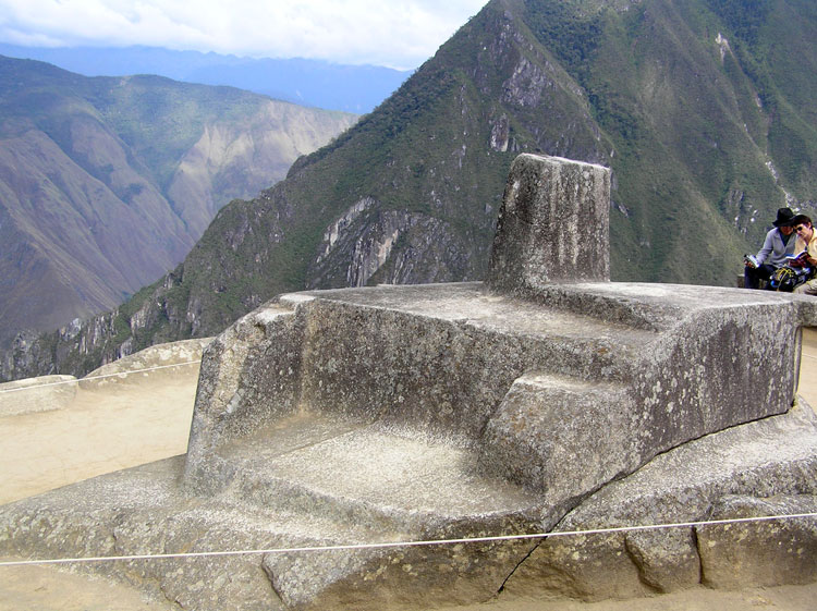
As described in chapter 3. this stone has been precision-carved from a single natural rock, and is positioned at the highest point of the ancient city, on a rocky hill-top, which has been carefully worked into a platform. In the 1930s, Dr Rolf Muller, a professor at the Astrophysical Institute of Potsdam in Germany, made the first detailed astronomical study of Machu Picchu and published his findings concerning it and other sites in South America.
Muller determined that the various inclined surfaces and angled sides of the Intihuatana were perfectly designed (at that particular geographical position and elevation) to enable the determination of sunset at the winter solstice, sunrise at the summer solstice, and sunset at both equinoxes.
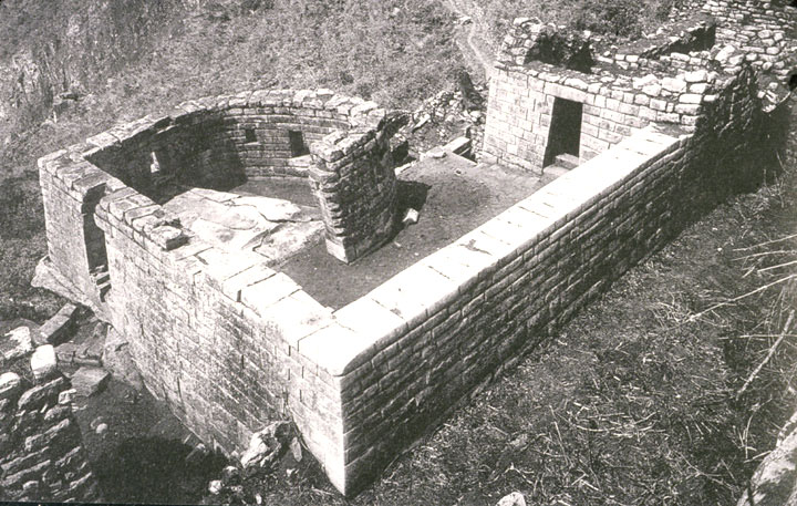
Moving to the nearby Torreon (meaning “the Tower”), Muller found that the two trapezoid windows in the semi-circular wall (see Plate 25) enabled the observation of sunrise at the summer and winter solstices. Applying the then controversial theory of archaeoastronomy, Rolf Muller arrived at the shocking conclusion that the astronomical alignments of the Intihuatana and Torreon were consistent with a 24-degree tilt in the Earth’s axis, thus dating them to around 2300-2100 BC.
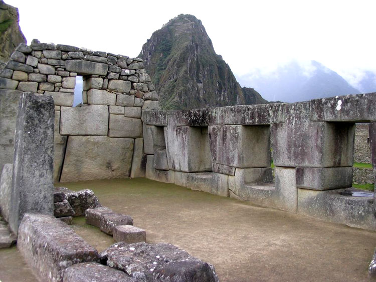
Muller’s findings were later confirmed by subsequent studies using more precise instruments, particularly by the astronomers Dearborn and White from the University of Arizona in the 1980s. Another scholar has recently suggested that the Temple of the Three Windows (Plate 22) might also have had astronomical alignments - to sunrise on midsummer day, equinox day and midwinter day. It has furthermore been suggested that the number of stone pegs in the Torreon and the Principal Temple (Plate 23) indicates a counting mechanism for a solar lunar calendar.
Plate 22 Plate 23
Three hundred and fifty miles south of Machu Picchu, lies the site of Tiwanaku in Bolivia (see chapter 3). One of the principal buildings at Tiwanaku is a temple known as the Kalasasaya, carefully constructed 4.5 degrees west of an exact east-west axis.
This temple was designed with built-in sight-lines, enabling precise determinations of equinoxes and solstices by observing sunrises and sunsets from various focal points along the sight-lines (anchored at the temple’s corners and the pillars erected at its western and eastern walls). It would seem that the Kalasasaya was nothing short of an ingenious celestial observatory.
Moreover, the presence of thirteen rather than twelve pillars in the western wall has led some to believe that it was not just a solar observatory but also a solar-lunar calendar. It is the dating of the Kalasasaya, however, which has caused the greatest controversy.
Arthur Posnansky, the
main researcher of Tiwanaku in the early twentieth century, found
that the alignments of the temple did not conform to the 23.5 degree
obliquity of the Earth in our present era. Using Sir Norman Lockyer’s then recently published theories of
archaeoastronomy,
together with the formulas determined by an International Conference
of astronomers in Paris in 1911, Posnansky dated Tiwanaku to around
15,000 BC!
Either date,
however, was a shock to the scientific community who had previously
thought the site to be no more than 2,000 years old. Muller
consequently joined forces with Posnansky in an attempt to resolve
the dating issue. Eventually they settled on a date of either 10050
BC or 4050 BC. The latter date is thought to be the more likely and
would happen to coincide exactly with the accepted date for the
beginning of agriculture and animal domestication in the Tiwanakan
region. It would seem that the expert builders and farmers of
Tiwanaku were also highly skilled astronomers.
However, by the time the Spaniards arrived, this extensive civilization had mysteriously vanished. The Maya left behind traces of an incredible culture, but one which the Spanish did their best to destroy. On one terrible night at Mani, in July 1562, Bishop Diego de Landa ordered the collection and burning of all the Mayan manuscripts and works of art, an act of vandalism which rivalled the burning of the Great Library of Alexandria:
It was fortunate perhaps that the jungle had already closed in to hide from the Spaniards the full extent of the great Mayan cities. It was more than two hundred and fifty years later when interest in the Maya revived, following the reports of great travellers such as Lord Kingsborough and John Lloyd Stephens. It was only then that the incredible achievements of the Maya began to be recognized.
Stephens saw in the jungle-choked ruins:
Attracted by Stephens descriptions, archaeologists began to reclaim
from the tropical rainforest a series of extraordinary Mayan cities,
with imposing palaces and eerie pyramid temples soaring above the
jungle canopy. Struggling to decipher the unusually complex Mayan
hieroglyphs, whose meanings had been lost in time,- these
archaeologists became more and more impressed by what they found.
These cities were ruled by priest kings and
controlled by dynastic families, linked by trade and marriage
alliances. The beautiful temples of the Maya were matched by
wonderful artistic achievements. In addition to their writing system
(formed of elaborate painted hieroglyphics), archaeologists have
found exquisite jade jewellery, highly advanced sculptures and
pottery-. and sophisticated works of art, beautifully crafted from
copper and gold.
For this we must thank three original Mayan books which are known to have Whilst Europe was in the Dark Ages. Survived to the present day, known as codices (picture-books), they are named after the cities in the museums of which they now reside:
The first two deal with astronomy and divination, the latter with rituals, Gods and astrology.
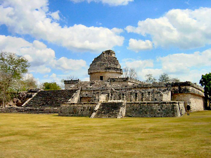
The experts admit that the Maya had in their possession astonishing facts concerning the Moon and the planet Venus, which they presume had been gleaned from long periods of observation. Mayan astronomical observatories have indeed been found, such as the El Caracol at Chichen Itza (Plate 38), where window-like openings in the tower were used to observe the equinoxes, It is worth briefly mentioning two examples which illustrate the amazing accuracy of the Mayan data.
First evidence from Copan (the astronomical centre) showed that the Maya had measured 149 lunar cycles as lasting 4,400 days; today’s astronomers make it 4,400.0575, and secondly, in the Dresden Codex, the period of Venus’ movement around the Sun was identified as a 584-day cycle compared to a current calculation of 583.92 days.
At the heart of the Mayan religion and science was an
incredibly sophisticated calendar, which used three different time
scales to date events in their history. The widespread use of this
dating system on stone stelae (upright columns) enabled it to be
deciphered quite quickly.
The first dating system, known as the
Long
Count, expressed the date as a number of days since Day Zero. which
occurred in 3113 BC. The significance of this date - long before the
beginning of Mayan civilization - has never been established (but
will be revealed in chapter 13). The second system used the more
conventional 365-day Solar Calendar, but with 12 months of 30 days
and a thirteenth month of 5 days.
The full significance of the number 52, however, remains a mystery. Despite their use of the approximate 365-day solar year, it is clear that the Maya were fully aware of the principle of adjusting the solar calendar, as we do today in “leap,’ years. It has been shown that they possessed accurate calculations of 365.2320 days for the solar year.
Since modern astronomy calculates the actual length of the year at 365.2422 days, the Mayan calendar was in fact marginally more accurate than the Gregorian calendar which we use today, based on 365.2425 days.
In order to record the Long Count, the Maya used an elaborate “base 20” mathematical system, which included the concept of zero and also the place concept whereby a “1” could represent 1. 20, 400 and so on (similar to our present day base 10 system!. Just as we today have special terms to describe “million” and “billion”, the Maya used a series of glyphs which culminated in the term alau-tun which represented 23,040,000,000.
The only apparent explanation for such
an advanced mathematical system is the Maya’s fascination with the
measurement of time, yet scholars are at a loss to explain why such
large numbers were required. The term alau-tun, applied to the Long
Count, represented a period of over 63 million years!
One book observes that:
Another book, devoted to the Maya, notes their “obsession with time” and describes their complex interlocking calendars as:
Today, Mayan remains the first language of around 250,000 people, but the previous high culture is gone. It is as if a knowledgeable elite disappeared from the scene, leaving behind their achievements to be consumed by the jungle. As to the origin of the Maya, that also remains an intriguing mystery. However, they were not the first high culture in Mesoamerica. Traces have been found of an earlier culture, known as the Olmecs, who possessed surprisingly advanced ceramics and jewellery.
Few books have much to say about the Olmecs, since little is known about their rise and fall, but James and Oliver Tickell refer to their:
The Olmecs, like the Maya, appeared as if from nowhere with advanced
astronomical skills. However, since the Olmec culture dates from c.
1500 BC, could it be that they, along with the Maya, were the
recipients of a legacy which dates back to at least 2100 BC in Peru
and to 4050 BC or earlier at Tiwanaku?
The Sirius Secret
Robert Temple began his studies following an earlier report by two French anthropologists, Marcel Griaule and Germaine Dieterlen, who claimed to have found knowledge of Sirius in four Sudanese tribes. The French scientists had focused their investigations on a people known as the Dogon, who lived in Mall, West Africa.
Between 1946 and
1950, they gathered information from four Dogon priests concerning
their sacred religious traditions. These traditions were apparently
based on a myth which had been passed down orally from one
generation to another. Every sixty years, the Dogon practiced a
ceremony known as Sigui, which re-enacted the re-creation of the
world by the God Amma, the crushing of the primitive Ogo-man. and
the subsequent granting of civilization by Amma’s son Nommo. The day
of the Gods’ arrival was known to the Dogon as the “day of the
fish”, and the Gods themselves were regarded as amphibious beings.
This is quite amazing, because Sirius B is a “white dwarf’, the tiniest form of visible star in the universe. As such, it is invisible to the naked eye, and barely visible even with a good telescope. If the tale was a myth, why did the Dogon not worship Sirius A, the so-called “dog star”, which is one of the brightest stars in the sky?
Robert Temple provides incontrovertible evidence that the Dogon knew of the existence of the invisible Sirius B. How could they have known? Some cynics have attributed this knowledge to visiting missionaries, but as Temple points out, these missionaries arrived more than a hundred years before Sirius B was photographed for the first time in 1970. Nor was the Dogon knowledge of astronomy restricted to Sirius.
Robert Temple also demonstrates that they knew of the Earth’s rotation on its axis and its 365-day solar orbit, which they split into a calendar of 12 months. As for the Moon, the Dogon knew that it was dry and dead and among their other remarkable knowledge (allegedly) is the existence of Saturn’s ring and Jupiter’s four largest satellites. Where did all this knowledge come from?
Temple concludes his research as follows:
Although based on an
erroneous notion, it is fitting that our day-to-day lives are still
linked so closely to astronomy. for it has been a continuing hobby,
indeed obsession, of mankind since the earliest civilization six
thousand years ago.
The starting point is the Earth’s spin on its axis, which gives us the easily recognizable phases of night and day. The next step is to understand that the Earth’s axis is tilted in its plane of orbit around the Sun (known as the obliquity of the ecliptic). This feature leads to the four seasons. The earliest civilizations were all quick to recognize four key points, by observation of the Sun’s risings and settings relative to the Earth’s horizon.
These four points are the summer and winter solstices (solar standstills) when the Sun reaches its outermost positions north and south, seems to hesitate and then turns back; and the spring and autumn equinoxes (when day and night are equal) on the two occasions in the year when the Sun crosses over the Earth’s equator.
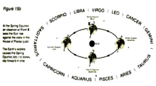
In addition, the Earth has a wobble, like a spinning top. For general purposes, it is usually assumed that an arrow drawn through the Earth’s axis, pointing to the heavens above the north pole,”’ remains fixed in its position. But this is not strictly true. Over a very lung period (approximately 25,920 years), the Earth’s wobble causes the arrow-point to move in the heavens, in a fashion which will eventually trace a 360-degree circle (Figure 15a).
As a result of this wobble, the starting points for the four seasons -when the Earth experiences its two solstices and two equinoxes - arrive slightly earlier each year. This effect, known as “precessional’, amounts to only one month in every 2160 years, so it is not something we would take much notice of. An important effect of the phenomenon, however, is to alter the backdrop of the stars at these four calendar points. It is conventional to measure precession at the point of the equinoxes - thus the full astronomical term is the precession of the equinoxes.
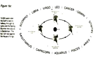
Thus we can use sunrise on the day of the spring equinox as a reference point to observe and measure the heavenly shift from one zodiac house to another. Right now, we are in the Age of Pisces and about to move into the Age of Aquarius (Figure 15b). whereas in approximately 13,000 years time our descendants will be in the Age of Virgo about to move into the Age of Leo (Figure 15c).
Figure 15b Figure 15c
In the nineteenth century, the astronomer Sir Norman Lockyer noticed that some ancient temples had been realigned after they were built. Intrigued by the continual realignment of temples as time progressed, particularly at Thebes (Karnak) in Egypt, Lockyer began to develop a comprehensive dossier on the astronomical alignment of numerous temples and cathedrals.
His conclusions, published in 1894
in his book The Dawn of Astronomy, caused a storm of controversy for
his theory suggested not only that the ancients had the astronomical
knowledge, but also that the temple alignments could be used as a
scientific method to date their construction. Like most
revolutionary scientific breakthroughs, it took the best part of a
century for his theories to gain wide acceptance.
This motion has been likened to the roll of a ship, but in slow motion, such that the horizons are raised and lowered almost imperceptibly. By a close examination of the exact alignment of ancient temples. Lockyer’s breakthrough has enabled us to make very close approximations of some construction dates. Those temples which are aligned to the solstices (and thus affected by the Earth’s tilt) can be dated using detailed tables of the Earth’s estimated tilt over the past several thousand years. In his book, Sir Norman Lockyer cited a range of temples with all types of celestial alignments.
As an example of a solsticial Sun Temple, he used the “Temple of Prayer for Good Harvests”, the most beautiful and most famous building in Beijing, China. It was here, at its south altar, that the most important state sacrifice was traditionally held on the day of the winter solstice. As examples of equinoctial temples, he cited the temple to Zeus at Baalbek in Lebanon, oriented on an exact east-west axis at its time of construction (Plate 1), the Temple of Solomon in Jerusalem and the great basilica of St. Peter’s in Vatican city, Rome.
Lockyer’s
breakthrough enabled a new science, archaeoastronomy, to be founded,
which could date the construction of stone temples which were
outside the scope of radiocarbon dating. Significantly, this science
could not exist without implicitly recognizing the astronomical
knowledge of ancient civilizations.
Most amazing of all, it would seem that our ancient ancestors knew of the 25,920-year precessional cycle. In a later chapter, we will be reviewing the widespread awareness of the precessional shift from Taurus to Aries over four thousand years ago. For now, we should note that in the second century BC, Hipparchus referred to “the displacement of the solsticial and equinoctial sign” - a clear reference to precession.
Where did Hipparchus acquire his knowledge’! In his writings, he credited various mentors, especially the “Babylonian astronomers of Erech, Borsippa and Babylon’’. We now know that the ancient Babylonians, known as the Chaldeans, were indeed very advanced in astronomy, but they in turn acquired their knowledge from an earlier civilization.
It was in Sumer - the very
first civilization - that astronomy began, and in Sumer that the
various signs were first attributed to the twelve houses of the
zodiac. It would seem that this earliest astronomy arose in a
perfected form, right at the very beginning of the Sumerian
civilization nearly six thousand years ago. But instead of
progressing, the level of astronomical expertise declined. Studies
have shown that the Babylonians, who succeeded the Sumerians in
Mesopotamia, used ephemeredes (lists of planetary movements) which
were less accurate.
When Copernicus placed the
Sun at the centre of the Solar System, it might have seemed, at the
time, a revolutionary suggestion. But Copernicus was not the first
to identify the true picture - he was only rediscovering what had
been known in ancient times. It may well be that Copernicus drew
directly from ancient sources of information, for there is no doubt
that pockets of ancient knowledge had survived, driven underground
into secret religious traditions. For instance, the thirteenth
century Zo‘har, a central work in the literature of Jewish
mysticism known as the Kabbalah, stated quite clearly that the Earth
turned around its own axis:
Another ancient epic, the Indian Vishnu Purana, repeated their long-held tradition that “the Sun is always in one and the same place”, whilst the Surya Siddhanta described Earth as “a globe in space” In the sixth century BC, Pythagoras taught his students that the Earth was a sphere. In the fifth century BC, the Ionian philosopher Anaxagoras explained that the Moon darkened the Sun during an eclipse, and that during a lunar eclipse the Earth’s shadow fell on the Moon.
In the third century BC, Aristarchus of Samos deduced that the Earth revolved around the Sun and the geographer Eratosthenes used geometry combined with astronomical knowledge to compute the circumference of the Earth with an error of less than 200 miles compared to modern geography. In China, during the second century AD, Chang Heng described the Earth as “an egg” and explained that its axis pointed to the Polar Star. The list goes on...
These astounding examples of ancient science are conveniently swept under the carpet, for to recognize them is to raise the inevitable question of how these people could possibly have acquired their knowledge and, in particular, how the Sumerians could have acquired astronomical knowledge in such a perfected form, with no evidence of any period of intellectual evolution.
The mysterious source of Sumerian astronomy prompts a number of further questions:
These are only some of the mysteries which
conventional science fails to answer.
The Sumerians could not possibly have needed such a sophisticated level of astronomy for agricultural purposes. On the contrary, the Sumerian obsession with beginning the New Year on the exact day of the spring equinox was driven by religion. Our survey of the “impossible”, and our search for a powerful motivating force, has brought us neatly back to what all of the ancient civilizations told us - that they were ruled by a technologically sophisticated race of “Gods”.
The Sumerians called them by names such as Anu, Enlil and Enki. The Egyptians called them by names such as Isis. Osiris and Horus. The Babylonians focussed on one God, Marduk. The Israelites were told to worship one God, Yahweh. The ancient people of the Americas worshipped Gods called Quetzalcoatl or Viracocha.
And in all of these lands there were
so-called myths of the Gods creating man and granting him
civilization and science. As we shall see in the following chapters,
these flesh-and blood Gods were the primary reason why ancient man
acquired such an obsessive interest in astronomy.
Back to The Modern Past - Ancient Hi Tech Evidences
|